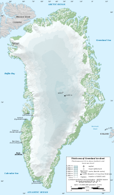
Greenland ice cap
| Greenland ice sheet | |
|---|---|

Outline map of Greenland with ice sheet depths. GISP2 refers to a main site of the Greenland Ice Sheet Project, where a 3 km (1.9 mi) deep ice core was taken.
|
|
| Type | Ice sheet |
| Coordinates | 76°42′N 41°12′W / 76.7°N 41.2°WCoordinates: 76°42′N 41°12′W / 76.7°N 41.2°W |
| Area | 1,710,000 km2 (660,000 sq mi) |
| Length | 2,400 km (1,500 mi) |
| Width | 1,100 km (680 mi) |
| Thickness | 2,000–3,000 m (6,600–9,800 ft) |
The Greenland ice sheet (Danish: Grønlands indlandsis, Greenlandic: Sermersuaq) is a vast body of ice covering 1,710,000 square kilometres (660,000 sq mi), roughly 80% of the surface of Greenland.
It is the second largest ice body in the world, after the Antarctic ice sheet. The ice sheet is almost 2,400 kilometres (1,500 mi) long in a north-south direction, and its greatest width is 1,100 kilometres (680 mi) at a latitude of 77°N, near its northern margin. The mean altitude of the ice is 2,135 metres (7,005 ft). The thickness is generally more than 2 km (1.2 mi) and over 3 km (1.9 mi) at its thickest point. It is not the only ice mass of Greenland – isolated glaciers and small ice caps cover between 76,000 and 100,000 square kilometres (29,000 and 39,000 sq mi) around the periphery. If the entire 2,850,000 cubic kilometres (684,000 cu mi) of ice were to melt, it would lead to a global sea level rise of 7.2 m (24 ft). The Greenland Ice Sheet is sometimes referred to under the term inland ice, or its Danish equivalent, indlandsis. It is also sometimes referred to as an ice cap.
The presence of ice-rafted sediments in deep-sea cores recovered from northeast Greenland, in the Fram Strait, and south of Greenland indicated the more or less continuous presence of either an ice sheet or ice sheets covering significant parts of Greenland for the last 18 million years. From about 11 million years ago to 10 million years ago, the Greenland Ice Sheet was greatly reduced in size. The Greenland Ice Sheet formed in the middle Miocene by coalescence of ice caps and glaciers. There was an intensification of glaciation during the Late Pliocene. Ice sheet formation occurred in connection to uplift of the West Greenland and East Greenland uplands. The Western and Easter Greenland mountains constitute passive continental margins that were uplifted in two phases, 10 and 5 million years ago, in the Miocene epoch.Computer modelling shows that the uplift would have enabled glaciation by producing increased orographic precipitation and cooling the surface temperatures. The oldest known ice in the current ice sheet is as old as 110,000 years.
...
Wikipedia
