Green Valley, Maryland
| Green Valley, Maryland | |
|---|---|
| Former census-designated place | |
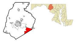
 Location of Green Valley, Maryland |
|
| Coordinates: 39°20′30″N 77°14′26″W / 39.34167°N 77.24056°WCoordinates: 39°20′30″N 77°14′26″W / 39.34167°N 77.24056°W | |
| Country | |
| State |
|
| County |
|
| Area | |
| • Total | 20.6 sq mi (53.4 km2) |
| • Land | 20.6 sq mi (53.4 km2) |
| • Water | 0.0 sq mi (0.0 km2) |
| Elevation | 397 ft (121 m) |
| Population (2000) | |
| • Total | 12,262 |
| • Density | 595/sq mi (229.8/km2) |
| Time zone | Eastern (EST) (UTC-5) |
| • Summer (DST) | EDT (UTC-4) |
| FIPS code | 24-35412 |
| GNIS feature ID | 0588667 |
Green Valley is an unincorporated area and former census-designated place (CDP) in southern Frederick County, Maryland, United States. The population was 12,262 at the 2000 census. The area was not listed as part of any CDP at the 2010 census.
The Green Valley area is located in southeastern Frederick County at 39°20′30″N 77°14′26″W / 39.34167°N 77.24056°W (39.341801, -77.240437), bordered to the south by Montgomery County. The northern edge of the CDP extended from Mount Airy in the northeast to New Market in the northwest. The unincorporated community of Monrovia is just to the west.
According to the United States Census Bureau, the Green Valley CDP had a total area of 20.6 square miles (53 km2), all of it land.
As of the census of 2000, there were 12,262 people, 3,882 households, and 3,470 families residing in the CDP. The population density was 595.1 people per square mile (229.8/km²). There were 3,928 housing units at an average density of 190.6/sq mi (73.6/km²). The racial makeup of the CDP was 95.91% White, 1.24% African American, 0.23% Native American, 0.99% Asian, 0.04% Pacific Islander, 0.38% from other races, and 1.22% from two or more races. Hispanic or Latino of any race were 1.69% of the population.
...
Wikipedia
