Green Creek (Fishing Creek)
| Green Creek | |
|---|---|

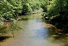
the lower reaches of Green Creek in late spring
|
|
| Etymology | named for the apparent color of its waters |
| Physical characteristics | |
| Main source | hill near Waller in Jackson Township, Columbia County, Pennsylvania 1,246 ft (380 m) |
| River mouth | Fishing Creek in Orange Township, Columbia County, Pennsylvania 561 ft (171 m) |
| Length | 12.7 mi (20.4 km) |
| Basin features | |
| Progression | Fishing Creek → Susquehanna River → Chesapeake Bay |
| Basin size | 36.8 sq mi (95 km2) |
| Tributaries |
|
Green Creek is a tributary of Fishing Creek in Columbia County, Pennsylvania, in the United States. It is approximately 12.7 miles (20.4 km) long and flows through Jackson Township, Greenwood Township, and Orange Township. The watershed of the creek has an area of 36.8 square miles (95 km2). Green Creek has three named tributaries: Little Green Creek, Rickard Hollow, and Mud Run. The creek is not designated as an impaired waterbody and is a relatively large stream, contributing a significant amount of water to Fishing Creek. A valley known as the Greenwood Valley is located in the vicinity of Green Creek. The creek's own valley was likely affected by glaciation during the Ice Age.
Soil erosion is a significant concern in some areas of the watershed of Green Creek, especially in the Greenwood Valley. A number of bridges have been constructed over the creek, including a covered bridge known as the Patterson Covered Bridge. Settlers arrived in the vicinity of the creek by the late 18th century and early 19th century, and a few mills of various were built on it in the 19th century. An Indian path also used to follow the creek for some distance.
The drainage basin of Green Creek is designated as a Trout Stocked Fishery and a Migratory Fishery. The creek itself contains brown trout. The creek has relatively narrow riparian buffers in some reaches. However, it has a hemlock-rich floodplain in Jackson Township.
Green Creek begins on a hill in Jackson Township, near the census-designated place of Waller. It flows south for a few tenths of a mile and enters Waller before turning south-southwest for a few tenths of a mile and leaving Waller. The creek then passes through a pond and turns south-southeast, flowing through a valley near the western border of Waller. After several tenths of a mile, it passes through two more ponds and turns south-southwest for a few tenths of a mile before turning south and then south-southwest, passing through another small pond. The creek eventually turns south-southwest for several tenths of a mile before turning south-southeast and entering Greenwood Township.
...
Wikipedia
