Great Stirrup Cay
| Great Stirrup Cay | |
|---|---|
| Island | |

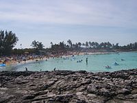
Beach at Great Stirrup Cay
|
|
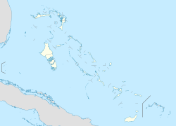
| Coordinates: 25°50′N 77°54′W / 25.833°N 77.900°WCoordinates: 25°50′N 77°54′W / 25.833°N 77.900°W | |
| Country |
|
| Island | Great Stirrup Cay |
| District |
|
| Population (2010) | |
| • Total | 5 |
| Time zone | Eastern Time Zone (UTC-5) |
| Area code(s) | 242 |

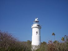
Lighthouse at Great Stirrup Cay
|
|
| Location | Great Stirrup Cay Berry Islands Bahamas |
|---|---|
| Coordinates | 25°49′24.7″N 77°54′03.1″W / 25.823528°N 77.900861°W |
| Year first constructed | 1863 |
| Construction | stone tower |
| Tower shape | cylindrical tower with balcony and lantern |
| Markings / pattern | white tower |
| Height | 17 metres (56 ft) |
| Focal height | 25 metres (82 ft) |
| Light source | solar power |
| Range | 20 nautical miles (37 km; 23 mi) |
| Characteristic | Fl (2) W 20s. |
| Admiralty number | J4626 |
| NGA number | 11952 |
| ARLHS number | BAH-022 |
| Managing agent | Little Whale Cay Resort |
Great Stirrup Cay is a small island that is part of the Berry Islands in the Bahamas. Norwegian Cruise Line purchased the island from the Belcher Oil Company in 1977 and developed it into a private island for their cruise ship passengers. The northern part of the island has a sandy beach surrounded by rocks with snorkeling areas. The southern part features a helicopter airfield (with a sign reading "Great Stirrup Cay International Airport"), a large area without vegetation, and numerous concrete blocks. These are all remnants of a previous U.S. military installation and satellite tracking station. The island's lighthouse was originally constructed in 1863 by the Imperial Lighthouse Service.
Great Stirrup Cay is adjacent to Little Stirrup Cay, Royal Caribbean Cruises' private island.
Great Stirrup Cay, along with the rest of the Bahamas, was formed by tectonic and glacial shifting. The first known settlers to the Bahamas were the Lucayan Indians, relatives of the Arawaks who populated the Caribbean around 600 A.D.
Great Stirrup was a pirate hideout while the British settled in Nassau and the larger islands until 1815. This time marks the first documented settlers of Great Stirrup, and many of the structures from this settlement still stand today. Charts of this era show simply "Stirrup's Cay".
"Stirrup's Cay" remained active during the American Civil War, as the Confederates wished to continue to export cotton to Europe. The island was used as a landfall for provisioning while Federal warships patrolled the area to thwart their efforts. After the abolition of slavery, the British began to slowly withdraw from the out island colonies, and the plantation at Great Stirrup was abandoned. Great Stirrup is the northern most island in a chain of islands known as the Berry Islands, and is situated in an area along the Northwest Providence Channel.
...
Wikipedia

