Great Barrier Reef Marine Park
|
Great Barrier Reef Marine Park Queensland |
|
|---|---|
|
IUCN category VI (protected area with sustainable use of natural resources)
|
|

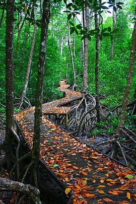
Boardwalk through a beautiful mangrove forest featured in Estuarine Conservation Zone as part of The Great Barrier Reef Marine Park
|
|
| Coordinates | 18°34′4″S 148°33′19″E / 18.56778°S 148.55528°ECoordinates: 18°34′4″S 148°33′19″E / 18.56778°S 148.55528°E |
| Established | 1975 |
| Area | 345,000 km2 (133,205.2 sq mi) |
| Managing authorities |
|
| Website | Great Barrier Reef Marine Park |
| See also | Protected areas of Queensland |
The Great Barrier Reef Marine Park protects a large part of Australia's Great Barrier Reef from damaging activities. It is a vast multiple-use Marine Park which supports a wide range of uses, including commercial marine tourism, fishing, ports and shipping, recreation, scientific research and Indigenous traditional use. Fishing and the removal of artefacts or wildlife (fish, coral, seashells, etc.) is strictly regulated, and commercial shipping traffic must stick to certain specific defined shipping routes that avoid the most sensitive areas of the park. The Great Barrier Reef is the largest and best known coral reef ecosystem in the world. Its reefs, almost 3000 in total, represent about 10 per cent of all the coral reef areas in the world. It is supports an amazing variety of biodiversity, providing a home to thousands of coral and other invertebrate species, bony fish, sharks, rays, marine mammals, marine turtles, sea snakes, as well as algae and other marine plants.
The Great Barrier Reef Marine Park Authority (GBRMPA) is responsible for the care and protection of the Great Barrier Reef Marine Park. It uses a range of tools to manage the marine park including Acts and Regulations, zoning plan, plans of management, Traditional Owner agreements, partnerships, stewardship and best practice, education, research and monitoring and reporting. It issues permits for various forms of use of the marine park, and monitors usage in the park to ensure compliance with rules and regulations associated with the park. GBRMPA is funded by Commonwealth Government appropriations and an environmental management charge levied on the permit-holders' passengers. Currently this is A$6.00 per day per passenger (to a maximum of $16.50 per trip).
The park lies east of the mainland coast of Queensland, starting in the north at Cape York. Its northern boundary is the circle of latitude 10°41'S (running east up to the eastern edge of the Great Barrier Reef at 145º19'33"E), thereby encompassing those few uninhabited Torres Strait Islands that are east of Cape York, south of 10°41'S and north of 11°00'S. The largest of those island are Albany Island (5.9 km2 or 2.3 sq mi), Turtle Head Island 12.8 km2 or 4.9 sq mi and Trochus Island 2.2 km2 or 0.85 sq mi. Further islands are Mai Island 0.25 km2 or 0.097 sq mi, Bush Island 0.2 km2 or 0.077 sq mi, Tree Islet 0.01 km2 or 0.0039 sq mi, Brewis Island 0.05 km2 or 0.019 sq mi, and a few unnamed islets.
...
Wikipedia

