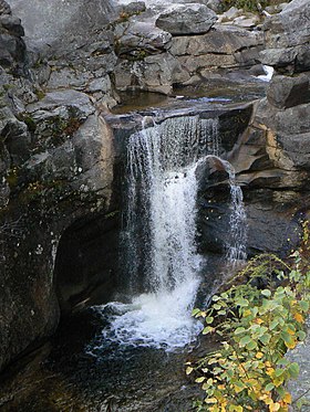
Grafton Notch State Park
| Grafton Notch State Park | |
| Maine State Park | |
|
Screw Augur Falls
|
|
| Country | |
|---|---|
| State | |
| County | Oxford |
| Township | Grafton |
| Elevation | 1,601 ft (488 m) |
| Coordinates | 44°35′36″N 70°56′52″W / 44.59333°N 70.94778°WCoordinates: 44°35′36″N 70°56′52″W / 44.59333°N 70.94778°W |
| Area | 3,129 acres (1,266 ha) |
| Established | 1963 |
| Management | Maine Department of Agriculture, Conservation and Forestry |
| Website: Grafton Notch State Park | |
Grafton Notch State Park is a public recreation area in Grafton Township, Oxford County, Maine. The state park occupies 3,129 acres (1,266 ha) surrounding Grafton Notch, the mountain pass between Old Speck Mountain and Baldpate Mountain. The park is abutted by the eastern and western sections of the Mahoosuc Public Reserved Land, which total 31,807 acres (12,872 ha). The park is managed by the Department of Agriculture, Conservation and Forestry.
In 1963, the state made its first acquisitions of the land for the park with the purchase of 2,875 acres (1,163 ha) from Brown Company. The addition of 18 more parcels, many less than 5 acres, took place in the 1960s, mostly in 1964. The park boundaries were fixed with the addition on two one-acre parcels in 1977.
The park's mountain scenery includes the Screw Auger and Mother Walker waterfalls and Moose Cave. Recreational opportunities include fishing, hunting, and picnicking. Hiking trails include a rugged 12-mile (19 km) stretch of the Appalachian Trail.
...
Wikipedia

