Graceville, Florida
| Graceville, Florida | |
|---|---|
| City | |

Welcome to Graceville Sign located on HWY 77
|
|
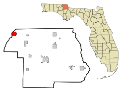
 Location in Jackson County and the state of Florida |
|
| Coordinates: 30°57′33″N 85°30′48″W / 30.95917°N 85.51333°WCoordinates: 30°57′33″N 85°30′48″W / 30.95917°N 85.51333°W | |
| Country |
|
| State |
|
| County | Jackson |
| Government | |
| • Mayor | Charles Holman |
| Area | |
| • Total | 4.4 sq mi (11.4 km2) |
| • Land | 4.3 sq mi (11.1 km2) |
| • Water | 0.1 sq mi (0.3 km2) |
| Elevation | 151 ft (46 m) |
| Population (2000) | |
| • Total | 2,402 |
| • Density | 545.9/sq mi (210.7/km2) |
| Time zone | Central (CST) (UTC-6) |
| • Summer (DST) | CDT (UTC-5) |
| ZIP code | 32440 |
| Area code(s) | 850 |
| FIPS code | 12-27000 |
| GNIS feature ID | 0283260 |
Graceville is a city in Jackson County, Florida, United States. The population was 2,278 at the 2010 census.
Graceville is located at 30°57′33″N 85°30′48″W / 30.95917°N 85.51333°W (30.959044, −85.513280).
Land area: 916 sq mi (2,370 km2). Region of the country: Southeast Average temperature: 67.2 Average high temperature: 79.0 Average low temperature: 55.0 Annual rain: 66.0 inches Annual snowfall: 0.0 inches Earthquake index: 0.0
Jackson County is a rural community primarily composed of business in agriculture, manufacturing, service, and retail trade. In addition, many government facilities are located within the county, including a federal prison and three state correctional institutions. Elevation ranges from 50 to 330 feet (100 m) above sea level. Marianna is 185 feet (56 m) above sea level.
Soil composition ranges from sandy to clay base. The most typical soil is sandy loam. Jackson County has a vast deposit of nearly pure limestone. The county abounds in lakes including Lake Seminole, Compass Lake, Merritt's Mill Pond and Ocheessee Pond. The Chattahoochee River-Apalachicola River, which is navigable and has a nine-foot channel depth, forms the county's eastern border. The Chipola River flows south through the center of the county.
As of the census of 2000, there were 2,402 people, 933 households, and 572 families residing in the city. The population density was 559.0 inhabitants per square mile (215.7/km²). There were 1,076 housing units at an average density of 250.4 per square mile (96.6/km²). The racial makeup of the city was 73.48% White, 23.90% African American, 0.92% Native American, 0.17% Asian, 0.25% from other races, and 1.29% from two or more races. Hispanic or Latino of any race were 1.46% of the population.
...
Wikipedia
