Government Center (MBTA station)
|
GOVERNMENT CENTER
GOVERNMENT CENTER
|
||||||||||||||||||||||||||||||||||||||||||
|---|---|---|---|---|---|---|---|---|---|---|---|---|---|---|---|---|---|---|---|---|---|---|---|---|---|---|---|---|---|---|---|---|---|---|---|---|---|---|---|---|---|---|

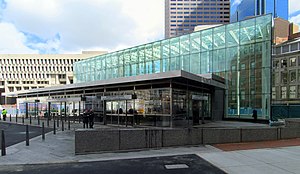
Government Center headhouse upon reopening in March 2016
|
||||||||||||||||||||||||||||||||||||||||||
| Location | 1 Cambridge St Boston, Massachusetts |
|||||||||||||||||||||||||||||||||||||||||
| Coordinates | 42°21′34″N 71°03′34″W / 42.35944°N 71.05944°WCoordinates: 42°21′34″N 71°03′34″W / 42.35944°N 71.05944°W | |||||||||||||||||||||||||||||||||||||||||
| Owned by | MBTA | |||||||||||||||||||||||||||||||||||||||||
| Line(s) | ||||||||||||||||||||||||||||||||||||||||||
| Platforms | 1 island platform (Blue Line) 1 triangular island platform (Green Line) |
|||||||||||||||||||||||||||||||||||||||||
| Tracks | Blue Line: 2 Green Line: 2 plus non-revenue loop track |
|||||||||||||||||||||||||||||||||||||||||
| Connections |
|
|||||||||||||||||||||||||||||||||||||||||
| Construction | ||||||||||||||||||||||||||||||||||||||||||
| Disabled access | Yes | |||||||||||||||||||||||||||||||||||||||||
| History | ||||||||||||||||||||||||||||||||||||||||||
| Opened | September 3, 1898 (Green Line) December 30, 1904 (Court Street station) March 18, 1916 (Blue Line) |
|||||||||||||||||||||||||||||||||||||||||
| Closed | November 15, 1914 (Court Street station) | |||||||||||||||||||||||||||||||||||||||||
| Rebuilt | March 22, 2014 – March 21, 2016 | |||||||||||||||||||||||||||||||||||||||||
| Previous names | Scollay Square (1898–1963) | |||||||||||||||||||||||||||||||||||||||||
| Traffic | ||||||||||||||||||||||||||||||||||||||||||
| Passengers (2013) | 10,828 (weekday average boardings) | |||||||||||||||||||||||||||||||||||||||||
| Services | ||||||||||||||||||||||||||||||||||||||||||
|
||||||||||||||||||||||||||||||||||||||||||
Government Center is an MBTA subway station located at the intersection of Tremont, Court and Cambridge Streets in the Government Center area of Boston. It is a transfer point between the light rail Green Line and the rapid transit Blue Line. With the Green Line platform having opened in 1898, the station is the third-oldest operating subway station (and the second-oldest of the quartet of "hub stations") in the MBTA system; only Park Street and Boylston are older. The station previously served Scollay Square before its demolition for the creation of Boston City Hall Plaza.
The station was closed on March 22, 2014 for a major renovation, which included retrofitting the station for handicapped accessibility and building a new glass headhouse on City Hall Plaza. The new fully accessible station was reopened on March 21, 2016.
The northern section of the Tremont Street Subway opened on September 3, 1898, with a station at Scollay Square. The station had an unusual platform design. The three-sided main platform served northbound and southbound through tracks plus the Brattle Loop track, one of two turnback points (along with Adams Square) for streetcars entering the subway from the north; a side platform also served the loopBoston Elevated Railway (BERy) streetcars from Everett, Medford, and Malden (which formerly ran to Scollay Square on the surface) used Brattle Loop, as did cars from Lynn and Boston Railroad and its successors. The last of those, the Eastern Massachusetts Street Railway, used the loop until 1935.
...
Wikipedia
