Goodman, Mississippi
| Goodman, Mississippi | |
|---|---|
| Town | |
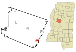
 Location of Goodman, Mississippi |
|
| Location in the United States | |
| Coordinates: 32°58′5″N 89°54′45″W / 32.96806°N 89.91250°WCoordinates: 32°58′5″N 89°54′45″W / 32.96806°N 89.91250°W | |
| Country | United States |
| State | Mississippi |
| County | Holmes |
| Government | |
| • Mayor | Debra Ann Mabry |
| Area | |
| • Total | 0.8 sq mi (2.1 km2) |
| • Land | 0.8 sq mi (2.1 km2) |
| • Water | 0.0 sq mi (0.0 km2) |
| Elevation | 266 ft (81 m) |
| Population (2000) | |
| • Total | 1,252 |
| • Density | 1,523.3/sq mi (588.2/km2) |
| Time zone | Central (CST) (UTC-6) |
| • Summer (DST) | CDT (UTC-5) |
| ZIP code | 39079 |
| Area code(s) | 662 |
| FIPS code | 28-28220 |
| GNIS feature ID | 0670500 |
Goodman is a town in Holmes County, Mississippi. The population was 1,252 at the 2000 census.
Goodman was settled in 1860; first chartered on November 16, 1865; and rechartered on March 5, 1878. The town is named for the first president of the Mississippi Central Railroad.
Goodman is the birthplace of John A. Lomax (1867–1948), pioneering folklorist, and David Herbert Donald (1920–2009), Pulitzer-prize-winning historian.
Goodman is located at 32°58′5″N 89°54′45″W / 32.96806°N 89.91250°W (32.968057, -89.912625).
According to the United States Census Bureau, the town has a total area of 0.8 square miles (2.1 km2), of which 0.8 square miles (2.1 km2) is land and 1.20% is water.
As of the census of 2000, there were 1,252 people, 280 households, and 206 families residing in the town. The population density was 1,523.3 people per square mile (589.5/km²). There were 303 housing units at an average density of 368.7 per square mile (142.7/km²). The racial makeup of the town was 65.81% African American, 33.23% White, 0.16% Native American, and 0.80% from two or more races. Hispanic or Latino of any race were 0.64% of the population.
...
Wikipedia

