Golfito (canton)
| Golfito | |
|---|---|
| Cantón | |
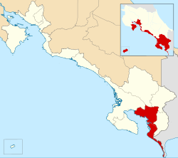
 Location of Golfito Canton in Puntarenas Province |
|
| Country | Costa Rica |
| Province | Puntarenas |
| Founded | 10 June 1949 |
| Area | |
| • Total | 1,753.96 km2 (677.21 sq mi) |
| Population (June 2013) | |
| • Total | 42,012 |
| • Density | 24/km2 (62/sq mi) |
Golfito is the seventh canton in the province of Puntarenas in Costa Rica. The canton covers an area of 1,753.96 km², and has a population of 42,012. Its capital city is also called Golfito.
The canton encompasses the southernmost Pacific coast of Costa Rica, north from Cerro Punta Gorda (Fat Point Hill) at the Panama border. It includes land on both sides of the Golfo Dulce (Sweet Gulf) and the entire southern portion of the Osa Peninsula.
The canton of Golfito is subdivided into 4 distritos (districts).
The canton was created by a decree of June 10, 1949.
Coordinates: 8°38′19″N 83°09′55″W / 8.638714°N 83.165321°W
...
Wikipedia
