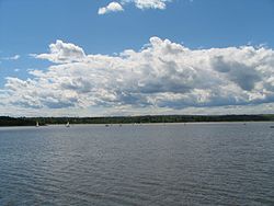
Glenmore Reservoir
| Glenmore Reservoir | |
|---|---|
 |
|
| Location | Calgary, Alberta |
| Coordinates | 50°59′21″N 114°06′49″W / 50.98917°N 114.11361°WCoordinates: 50°59′21″N 114°06′49″W / 50.98917°N 114.11361°W |
| Lake type | reservoir |
| Primary inflows | Elbow River |
| Primary outflows | Elbow River |
| Catchment area | 1,210 km2 (470 sq mi) |
| Basin countries | Canada |
| Max. length | 4.1 km (2.5 mi) |
| Max. width | 0.9 km (0.56 mi) |
| Surface area | 3.84 km2 (1.48 sq mi) |
| Average depth | 6.1 m (20 ft) |
| Max. depth | 21.1 m (69 ft) |
| Surface elevation | 1,080 m (3,540 ft) |
The Glenmore Reservoir is a large artificial reservoir on the Elbow River in the southwest quadrant of Calgary, Alberta. The Glenmore Dam is the concrete structure that holds back the reservoir. The reservoir is a primary source of drinking water to the city. Built in 1932, with a cost of $3.8 million, the dam controls the downstream flow of the Elbow River, thus allowing the city to develop property near the river's banks with less risk of flooding.
The reservoir has a water mirror of 3.84 km2 (1.48 sq mi) and a drainage basin of 1,210 km2 (470 sq mi).
In 2014, the city announced plans to upgrade the dam at a cost of $81 million.
Calgary pioneer Sam Livingston originally settled at the location of the reservoir, and he gave the name Glenmore (Gaelic for "big valley") to this area.
The dam was completed on January 31, 1933 and was designed by William Gore and Bill Storie. When the area flooded (by the summer of 1933), part of the Livingston house was preserved and now stands in Heritage Park, which borders on the reservoir.
Although the dam usually provides effective flood protection, a major flood in June 2005 caused the reservoir to exceed its capacity. The excess spilled over the dam and into the river. The flow downstream increased from its normal average of 20-30 cubic metres per second up to 350 cubic metres per second. As a result, some roads were closed and 2,000 Calgarians who lived downstream were evacuated. The Glenmore water treatment plant had difficulty treating the heavily silted water, which caused the municipal government to issue water restrictions. The Alberta government estimated the floods in the area to be the heaviest flooding in at least two centuries.
In June 2013, heavy rainfall west of the city caused the reservoir to exceed its capacity. As it did in 2005, excess water spilled over the dam and into the Elbow river with downstream flows up to 544 cubic metres per second. 75,000 people from 26 neighbourhoods in the vicinity of the Bow and Elbow rivers were placed under a mandatory evacuation order as the rivers spilled over their banks and flooded neighbourhoods. City officials urged Calgarians, particularly the 350,000 people who work downtown, to stay home and limit non-essential travel. Unlike the 2005 flood, the Glenmore water treatment facility had no difficulty treating water. City officials did, however, implement municipal outdoor watering restrictions to ensure water quality remained high throughout the incident. Government officials called the flooding the worst in Alberta's history. This flood prompted a local Erlton resident to propose the Heritage Drive Tunnel Spillway as a way to divert 500 cubic metres per second of water around the downtown core and into the lower Bow River.
...
Wikipedia
