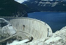
Gibson Dam
| Gibson Dam | |
|---|---|
 |
|
| Country | United States |
| Location | Lewis and Clark/Teton Counties, Montana |
| Coordinates | 47°36′12″N 112°45′39″W / 47.60333°N 112.76083°WCoordinates: 47°36′12″N 112°45′39″W / 47.60333°N 112.76083°W |
| Purpose | Irrigation |
| Construction began | 1926 |
| Opening date | 1929 |
| Dam and spillways | |
| Type of dam | Concrete arch |
| Impounds | Sun River |
| Height | 199 ft (61 m) |
| Length | 960 ft (290 m) |
| Reservoir | |
| Creates | Gibson Reservoir |
| Total capacity | 96,477 acre·ft (119,003,000 m3) |
| Catchment area | 575 sq mi (1,490 km2) |
| Surface area | 1,296 acres (524 ha) |
Gibson Dam is a concrete arch dam on the Sun River, a tributary of the Missouri River, about 60 miles (97 km) west of Great Falls, Montana in the United States. Located on the eastern edge of the Rocky Mountains, the dam was built by the U.S. Bureau of Reclamation (USBR) between 1926 and 1929 as part of the Sun River Project to develop about 93,000 acres (38,000 ha) of irrigated land in the Sun River Valley.
The dam is a 199 ft (61 m) high and 960 ft (290 m) long arch gravity structure, with a base thickness of 115 ft (35 m) tapering to 15 ft (4.6 m) at the crest. As a whole the dam contains about 167,500 cu yd (128,100 m3) of concrete. The impounded water forms Gibson Reservoir, which can store up to 96,477 acre·ft (119,003,000 m3) at full water levels of 4,724 ft (1,440 m). When full, the reservoir covers 1,296 acres (524 ha), with a shoreline of roughly 15 mi (24 km) and a maximum depth of 195 ft (59 m). Water releases are controlled by two sets of outlets: three release valves at the base of the dam have a combined capacity of 3,050 cu ft/s (86 m3/s), while a gated tunnel spillway, controlled by six 34x12 ft (10x4 m) radial gates, can pass a maximum of 30,000 cu ft/s (850 m3/s).
Gibson Dam's main function is to capture spring snowmelt and release it during summer for the irrigation for about 81,000 acres (33,000 ha) of land on the north side of the Sun River and 10,150 acres (4,110 ha) south of the river. Water released from Gibson travels downstream for about 3 mi (4.8 km) before it is intercepted by the Sun River Diversion Dam, which diverts water into the Pishkun Supply Canal, which sends water to the offstream Pishkun Reservoir. The Sun River Slope Canal System takes water from Pishkin Reservoir to serve the irrigated lands on the north side of the river. The headworks for the Fort Shaw Canal, which serves the lands south of the river, are located further downstream and take water directly from the river. The lands north of the river comprise the Greenfields Irrigation District, while the south side is run by the Fort Shaw Irrigation District.
On September 26, 1906, the Department of the Interior authorized the USBR's Sun River Project, under pressure from local residents, namely those of Great Falls, who wanted the irrigation of lands east of the Rocky Mountains along the Sun and Teton Rivers. Early proposals included the diversion of streams from west of the Continental Divide to augment the arid region's water supply, but eventually the project was pared down to comprise two storage dams on the Sun River and a tributary, Willow Creek; two off-stream reservoirs and a diversion dam; and seven main canals.
...
Wikipedia
