Gerringong, New South Wales
|
Gerringong New South Wales |
|
|---|---|

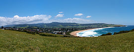
A view of the town from the south
|
|
| Coordinates | 34°45′S 150°50′E / 34.750°S 150.833°ECoordinates: 34°45′S 150°50′E / 34.750°S 150.833°E |
| Population | 3,456 (2011 census) |
| Established | 1854 |
| Postcode(s) | 2534 |
| Location | |
| LGA(s) | Municipality of Kiama |
| State electorate(s) | Kiama |
| Federal Division(s) | Gilmore |
Gerringong is a town located about ten minutes south of Kiama in the Illawarra region of New South Wales, Australia in the Municipality of Kiama. At the 2011 census, Gerringong had a population of 3,456 people. One theory says that the name derives from an Aboriginal word meaning "fearful place".
The first European settlers were red cedar cutters, who were first recorded as having visited and logged in the area in 1814. As in much of coastal New South Wales, the cleared land was used for dairy farming and cedar cutting died out, as the cedar trees disappeared. Dairy farming became the predominant primary industry and remains so to this day. Gerringong had a small boat harbour used for the export of cedar and dairy produce.
In 1824, Governor Brisbane reserved 600 acres (2.4 km²) for the present Gerringong township. In 1827, Michael Hindmarsh and his family were granted 640 acres (2.6 km²) and became the first settler in the Gerringong area. In 1829, Gerringong was incorporated into the postal system. Alne Bank homestead was built in 1851 for the Hindmarsh family, who still live there today and occasionally open it for inspection.
In 1854, a town plan for Gerringong was approved and the Governor proclaimed it a village. In 1872, the business area, Church of England church and some houses were destroyed by a bush fire. In 1893, the South Coast railway line was extended to Gerringong, leading to the end of shipping from the town. Telephone services were extended to Gerringong in 1913 and electricity in 1928.
In 1954, Gerringong Municipal District amalgamated with Kiama Municipal Council. The town water supply was connected in 1971, signalling an end to tanks attached to each house. Land along the coastal fringe tends to receive higher rainfall than the interior water catchment areas, which are often in rainshadow. In 2002, the town sewerage system was connected.
...
Wikipedia

