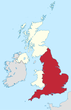
Geography of England
|
|
|
|
|
|
| Continent | Europe |
| Subregion | Great Britain Western Europe |
|
Area - Total - Land (%) - Water (%) |
130,395 km2 (50,346 sq mi) 98% 2% |
| Coastline | 3,200 km (1,988 mi) |
| Land borders |
Scotland 96 km (60 mi) Wales 257 km (160 mi) |
| Highest point |
Scafell Pike 978 m (3,209 ft) |
| Lowest point | Holme Fen, −2.75 m (−9 ft) |
| Longest river |
River Severn (shared with Wales) 354 km (220 mi) Longest river entirely within England is the River Thames 346 km (215 mi) |
| Largest inland body of water |
Windermere 14.73 km2 (5.69 sq mi) |
| Climate: |
Oceanic "British" climate with small areas of Subarctic climate |
| Terrain: | low mountains, hills, forests, lowlands, urban |
| Natural resources | iron, zinc, potash, silica sand, fish, timber, wildlife, petroleum, natural gas, hydropower, wind power, lead, tin, copper, china clay, arable land, and coal |
| Natural hazards | European Windstorms, floods, few and small Tornadoes |
| Environmental issues | climate change, rising sea levels, renewable energy, waste disposal, water pollution, population density |
| England 1971–2000 | ||||||||||||||||||||||||||||||||||||||||||||||||||||||||||||
|---|---|---|---|---|---|---|---|---|---|---|---|---|---|---|---|---|---|---|---|---|---|---|---|---|---|---|---|---|---|---|---|---|---|---|---|---|---|---|---|---|---|---|---|---|---|---|---|---|---|---|---|---|---|---|---|---|---|---|---|---|
| Climate chart () | ||||||||||||||||||||||||||||||||||||||||||||||||||||||||||||
|
||||||||||||||||||||||||||||||||||||||||||||||||||||||||||||
|
||||||||||||||||||||||||||||||||||||||||||||||||||||||||||||
| J | F | M | A | M | J | J | A | S | O | N | D |
|
84
7
1
|
60
7
1
|
67
9
2
|
57
12
4
|
56
15
6
|
63
18
9
|
54
21
11
|
67
21
11
|
73
18
9
|
84
14
7
|
84
10
4
|
91
7
2
|
| Average max. and min. temperatures in °C | |||||||||||
| Precipitation totals in mm | |||||||||||
| Imperial conversion | |||||||||||
|---|---|---|---|---|---|---|---|---|---|---|---|
| J | F | M | A | M | J | J | A | S | O | N | D |
|
3.3
44
34
|
2.4
44
34
|
2.6
49
36
|
2.2
53
38
|
2.2
60
43
|
2.5
65
48
|
2.1
69
53
|
2.6
69
52
|
2.9
64
49
|
3.3
56
44
|
3.3
49
38
|
3.6
45
36
|
| Average max. and min. temperatures in °F | |||||||||||
| Precipitation totals in inches | |||||||||||
...
Wikipedia


