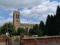
Gedney Drove End
| Gedney | |
|---|---|
 Gedney St Mary Magdalene church - the Cathedral of the Fens |
|
| Gedney shown within Lincolnshire | |
| Population | 2,351 (2011) |
| OS grid reference | TF405243 |
| • London | 85 mi (137 km) S |
| District | |
| Shire county | |
| Region | |
| Country | England |
| Sovereign state | United Kingdom |
| Post town | SPALDING |
| Postcode district | PE12 |
| Dialling code | 01406 |
| Police | Lincolnshire |
| Fire | Lincolnshire |
| Ambulance | East Midlands |
| EU Parliament | East Midlands |
| UK Parliament | |
Gedney is a village, civil parish and electoral ward in the South Holland district of Lincolnshire, England. It is situated just to the south of the A17 Boston to King's Lynn road, 2 miles (3.2 km) east from Holbeach and 2 miles (3.2 km) north-west from Long Sutton. The parish stretches east to The Wash, its villages and hamlets including Gedney Drove End, Gedney Dyke, Gedney Dawsmere, Gedney Marsh, and the geographic extension of Gedney Church End.
A hospital for five paupers, (St Thomas Martyr), was founded at Gedney, date unknown, and served from North Creake. It was dissolved around 1339.
The redundant railway station was on the former east-west Midland and Great Northern Joint Railway. It closed in 1959.
The Red House wind farm was built in 2006 with six MM82 wind turbines, its 12MW of power feeding 6,500 homes.
Gedney and its parish lies on reclaimed fenland, making it one of the most intensive crop-growing areas in the UK.
To the west, the parish begins at the eastern end of the Fleet Hargate bypass, and includes the village's campsite and a few houses, bordering the parish of Fleet. The boundary passes close to the west of Gedney Dyke, and meets the parish of Holbeach. It passes just to the west of Gedney Dyke Farm then follows Fleet Haven, near to the wind farm to the west of nearby Red House Farm.
It deviates to the east from Fleet Haven and passes to the west of (another) Red House Farm then rejoins Fleet Haven just south of Wards Farm. Fleet Haven runs out of land and meets the sea wall. In the parish, and close to the east is the base of RAF Holbeach which is accessed via Durham's Road. The parish extends out on the mud flats along Fleet Haven Outfall. To access the part of the parish along the start of The Wash would be extremely foolish and is out of bounds due to the bombing range. The limit of the parish finishes between Gat Sea End and Old South Middle. There are observation towers on the sea wall for the bombing range. The control tower is on the sea wall towards Dawsmere and Gedney Drove End. Dawsmere Creek extends out towards The Wash. The boundary with Lutton is along Boatmere Creek then extends out to sea along Tycho Wing's Channel, which is the outflow of the River Nene. This area is the far west of The Wash NNR.
...
Wikipedia

