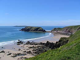
Gateholm Island

Gateholm from the north-east. Skokholm is in the distance
|
|
| Geography | |
|---|---|
| Location | Marloes |
| Coordinates | 51°43′05″N 5°13′53″W / 51.71806°N 5.23139°W |
| Administration | |
|
Wales
|
|
| County | Pembrokeshire |
Gateholm is a small tidal island off the south west coast of Pembrokeshire in the south west side of Wales, in the west of the UK, and about 13km west of the port of Milford Haven. It is known for its Romano-British remains.
The name, recorded as Goteholme in 1480, derives from Old Norse for "goat island".
Gateholm is at the western end of Marloes Sands, and is accessible only at low tide. Gateholm rises to a small plateau 40 metres (131 feet) high, and with an area of about 4 hectares (10 acres). The island consists of steeply-dipping Old Red Sandstone. The rock strata date from the Prídolí Epoch of the Silurian; the exceptional exposure here and on the adjoining Albion Sands have resulted in the location's inclusion in the Geological Conservation Review as a candidate for protection as a geological site of special scientific interest (SSSI).
The island contained around 130 roundhouses as well as huts of a rectangular shape. The rectangular houses were mostly arranged in rows end-on and surrounded by small courtyards. Excavations of some of these hut sites conducted in 1910 and 1930 found evidence for occupation in the Roman period, with finds including pottery, coins, and a small bronze stag. Of particular interest was the discovery of a bronze pin of Irish origin and dating from the 6th century. One of the houses had a stone phallus buried upright in one of the main post holes. The houses were built of turf with stone facings, the roof being carried on a ridge-pole between the posts. The site has been interpreted variously as a native Romano-British settlement with later occupation, and as an early monastic complex.
...
Wikipedia

