Garrison, Montana
| Garrison, Montana | |
|---|---|
| CDP | |
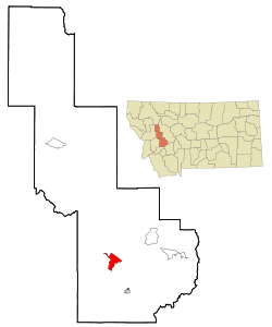
 Location of Garrison, Montana |
|
| Coordinates: 46°32′15″N 112°49′35″W / 46.53750°N 112.82639°WCoordinates: 46°32′15″N 112°49′35″W / 46.53750°N 112.82639°W | |
| Country | United States |
| State | Montana |
| County | Powell |
| Area | |
| • Total | 9.5 sq mi (24.7 km2) |
| • Land | 9.5 sq mi (24.7 km2) |
| • Water | 0.0 sq mi (0.0 km2) |
| Elevation | 4,373 ft (1,333 m) |
| Population (2000) | |
| • Total | 112 |
| • Density | 11.7/sq mi (4.5/km2) |
| Time zone | Mountain (MST) (UTC-7) |
| • Summer (DST) | MDT (UTC-6) |
| ZIP code | 59731 |
| Area code(s) | 406 |
| FIPS code | 30-30175 |
| GNIS feature ID | 0771720 |
Garrison is a census-designated place (CDP) in Powell County, Montana, United States. The population was 112 at the 2000 census.
The traditional Salish name for Garrison Junction is snx̣ʷq̓pusaqs. Groups would split up here, with some going towards Helena, others towards Butte.
A post office called Garrison was established in 1883, and remained in operation until 1980. The community was named for William Lloyd Garrison, an abolitionist. who was also the father-in-law of Henry Villard, the man who finally pushed the Northern Pacific Railroad to completion in 1883. Garrison is just east of Gold Creek, Montana, where the 'golden spike' was driven on Sept. 8, 1883 to mark the completion of the line. Among others present for the occasion was former President Ulysses S. Grant.
Garrison is located at 46°32′15″N 112°49′35″W / 46.53750°N 112.82639°W (46.537526, -112.826435).
According to the United States Census Bureau, the CDP has a total area of 9.5 square miles (25 km2), all land.
As of the census of 2000, there were 112 people, 50 households, and 34 families residing in the CDP. The population density was 11.7 people per square mile (4.5/km²). There were 63 housing units at an average density of 6.6 per square mile (2.5/km²). The racial makeup of the CDP was 91.96% White, 4.46% Native American, and 3.57% from two or more races. Hispanic or Latino of any race were 1.79% of the population.
...
Wikipedia
