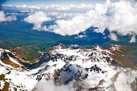
Garmo Peak
| Mount Garmo | |
|---|---|

The Pamirs
|
|
| Highest point | |
| Elevation | 6,595 m (21,637 ft) |
| Prominence | 1,265 metres (4,150 ft) |
| Coordinates | 38°48′N 72°4′E / 38.800°N 72.067°ECoordinates: 38°48′N 72°4′E / 38.800°N 72.067°E |
| Geography | |
| Location | Tajikistan, northwestern Gorno-Badakhshan |
| Parent range | Pamir Mountains |
Mount Garmo (Tajik: Қуллаи Гармо, Qullai Garmo, Russian: пик Гармо, pik Garmo) is a mountain of the Pamirs in Tajikistan, Central Asia, with a height reported to be between 6,595 metres and 6,602 metres.
There is a glacier on Mount Garmo, and the great Fedchenko Glacier (the longest glacier in the world outside the polar regions) flows to the east of it. The nearest settlement is at Poimazor, some fifteen kilometres to the south (38° 39' 10 N, 71° 58' 2 E), which is at an altitude of 2785 metres.
There has been some uncertainty about the location of Garmo and also about the true height of the peak which now bears that name. While the present consensus is around 6,595 metres, as recently as 1973 the American Alpine Journal gave the height as 21,703 feet (6,615 m).
Formerly in the Soviet Union, Garmo forms part of the Academy of Sciences Range (Russian: Хребет Академии Наук; Tajik: Qatorkuhi Akademiyai Fanho) where it connects with the Darvoz Range.
A Russian expedition to the region in 1928 made the first ascent of Lenin Peak and also measured the height of what is now officially called Ismoil Somoni Peak, which may have been mistakenly identified with Garmo although it lies some sixteen kilometres to the north of the present Garmo.
In July 1962, two British climbers, Wilfrid Noyce and the young Scottish climber Robin Smith, died in a 4,000-foot (1,200 m) fall after an ascent of the peak, while preparing for a Soviet-British assault on Ismoil Somoni, which was then known as Pik Kommunizma (Peak Communism).
...
Wikipedia

