Garden District, New Orleans
| Garden District | |
| New Orleans neighborhood | |
|
Streetcar on St. Charles Avenue in the Garden District with Mardi Gras beads on a tree in the foreground
|
|
| Country | United States |
|---|---|
| State | Louisiana |
| City | New Orleans |
| Planning District | District 2, Central City/Garden District |
| Elevation | 3 ft (0.9 m) |
| Coordinates | 29°55′40″N 90°05′05″W / 29.92778°N 90.08472°WCoordinates: 29°55′40″N 90°05′05″W / 29.92778°N 90.08472°W |
| Area | 0.21 sq mi (0.5 km2) |
| - land | 0.21 sq mi (1 km2) |
| - water | 0.00 sq mi (0 km2), 0% |
| Population | 1,179 (2010) |
| Density | 5,614/sq mi (2,168/km2) |
| Timezone | CST (UTC-6) |
| - summer (DST) | CDT (UTC-5) |
| Area code | 504 |
|
Garden District
|
|

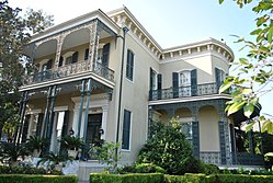
Colonel Short's Villa
|
|
| Location | Bounded by Carondelet, Josephine, and Magazine Sts., and Louisiana Ave., New Orleans, Louisiana |
|---|---|
| Built | 1835 |
| Architect | Multiple |
| Architectural style | Mid 19th Century Revival, Late Victorian |
| NRHP Reference # | 71000358 |
| Significant dates | |
| Added to NRHP | June 21, 1971 |
| Designated NHLD | May 30, 1974 |
The Garden District is a neighborhood of the city of New Orleans, Louisiana, United States. A subdistrict of the Central City/Garden District Area, its boundaries as defined by the City Planning Commission are: St. Charles Avenue to the north, 1st Street to the east, Magazine Street to the south, and Toledano Street to the west. The National Historic Landmark district extends a little farther.
The area was originally developed between 1832 and 1900 and is considered one of the best-preserved collections of historic mansions in the Southern United States. The 19th-century origins of the Garden District illustrate wealthy newcomers building opulent structures based upon the prosperity of New Orleans in that era. (National Trust, 2006)
The Garden District is located at 29°55′40″N 90°05′05″W / 29.92778°N 90.08472°W and has an elevation of 3 feet (0.9 m). According to the United States Census Bureau, the district has a total area of 0.21 square miles (0.5 km2). 0.21 square miles (0.5 km2) of which is land and 0.00 square miles (0.0 km2) (0.0%) of which is water.
The City Planning Commission defines the boundaries of the Garden District as these streets: St. Charles Avenue, 1st Street, Magazine Street and Toledano Street.
The Garden District Association defines the boundaries as both sides of Carondelet Street, Josephine Street, both sides of Louisiana Avenue, and Magazine Street.
...
Wikipedia


