Gandara, Samar
|
Gandara Bangahon |
|
|---|---|
| Municipality | |
 |
|
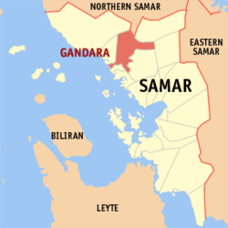
 Map of Samar with Gandara highlighted |
|
| Location within the Philippines | |
| Coordinates: 12°01′N 124°49′E / 12.017°N 124.817°ECoordinates: 12°01′N 124°49′E / 12.017°N 124.817°E | |
| Country | Philippines |
| Region | Eastern Visayas (Region VIII) |
| Province | Samar |
| District | 1st district of Samar |
| Barangays | 69 |
| Government | |
| • Mayor | Eufemio Delos Santos Oliva |
| • Vice Mayor | Felomina R. Cabuenos |
| Area | |
| • Total | 573.49 km2 (221.43 sq mi) |
| Population (2015 census) | |
| • Total | 34,434 |
| • Density | 60/km2 (160/sq mi) |
| Time zone | PST (UTC+8) |
| ZIP code | 6706 |
| IDD : area code | +63 (0)55 |
| Income class | 2nd municipal income class |
| 086007000 | |
| Electorate | 21,338 voters as of 2016 |
| Website | elgu |
Gandara is a 2nd class municipality in the province of Samar, Philippines. According to the 2015 census, it has a population of 34,434 people.
The town was formerly named Bangahon, but its population was resettled to its current location on September 29, 1902. After settling in its new location, the name Gandæra was given to it in commemoration of the former Governor General José de la Gándara y Navarro.
During the 9th century, after the Mesopotamian exploration the Hindus explored the Cambaye Island, they bring Sabai Grass seedlings, Negritos and the Hindus help together to grow the Grass, when the grass are ripe enough they harvest it and sundried it, Sabai fibres were extracted from Sabai Grasses, they weave the dried grass and turn it into dresses by using a catgut as a weaver.
On the 13th century an Arabian-British explorer built and structured this sea farer guide from an Scree with the help of a Negrito inhabitants located nearby with China White as an ingredient as building material, it is lit with a Western Incandescent lamp and powered by a Baghdad Carbon Cell, the said battery is charged by sun at day.
Gandæra's colonial past is evident from the solitary watchtower, the Friars returned after the remaining crew of Magellan came back from Spain, and situated along the Village called Dapdap and their Shrine called Tinago in 1596, and created a Cabecera called Catbalogan, and the Bangahon Church, the relics of the church and fragmented artworks. Statues of saints are of numbers one of which is the St. Niño (An infant Child) a White statue carved from wood and being tell that it is a pair of the Black statue of the St. Niño of Cebu the Magellan remnants they called the Black and White saints. The White statue is being told that a clan "Correche" is now being held it privately. Townspeople quarried the stones from Napalisan cliff or scree carried to Dapdap and then formed and constructed the Tinago Shrine and the church from what they called Galut a clay or Feldspar, Kaolinite used to make a pot or in a pottery business in Bangahon for the church of Bangahon. These are remants from the old Gandæra, named Bangahon due to its geographical location in the forked of the Gandæra River. "Guin babanga han wala ug too nga salug". The book Conquistas de las Islas Filipinas by Gaspar de San Agustin the Bangahon states it was already a Pueblo or town in 1729, and was made a parish by the Spanish Jesuits Missionaries with St. Michael the Archangel as patron saint.
...
Wikipedia

