Gamagōri, Aichi
|
Gamagōri 蒲郡市 |
|||
|---|---|---|---|
| City | |||

Takeshima
|
|||
|
|||
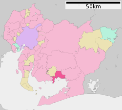
 Location of Gamagōri in Aichi Prefecture |
|||
| Coordinates: 34°50′35″N 137°13′10.5″E / 34.84306°N 137.219583°ECoordinates: 34°50′35″N 137°13′10.5″E / 34.84306°N 137.219583°E | |||
| Country | Japan | ||
| Region | Chūbu (Tōkai) | ||
| Prefecture | Aichi Prefecture | ||
| Government | |||
| • Mayor | Hisao Kanehara | ||
| Area | |||
| • Total | 56.89 km2 (21.97 sq mi) | ||
| Population (December 2015) | |||
| • Total | 81,332 | ||
| • Density | 1,430/km2 (3,700/sq mi) | ||
| Time zone | Japan Standard Time (UTC+9) | ||
| - Tree | Camphor Laurel | ||
| - Flower | Azalea | ||
| Phone number | 0533-66-1111 | ||
| Address | 17-1 Asahi-chō, Gamagōri-shi, Aichi-ken 443-8601 | ||
| Website | www |
||
Gamagōri (蒲郡市 Gamagōri-shi?) is a city in Aichi Prefecture, Japan.
As of December 2015[update], the city has an estimated population of 81,332 and a population density of 1,430 persons per km². The total area was 56.81 square kilometres (21.93 sq mi).
Gamagōri is situated on the coast of Mikawa Bay on the Pacific Ocean in southeastern Aichi Prefecture. Sheltered by Chita Peninsula and Atsumi Peninsula, the climate is mild, and parts of the city is within the borders of the Mikawa Wan Quasi-National Park.
Records of place names in present-day Gamagōri have been found from the Nara period. The area was divided into several shōen during the Heian period, largely under the control of the Udono clan. During the Edo period, most of the area was tenryō territory ruled directly by the Tokugawa shogunate through hatamoto administrators, with portions controlled by Yoshida Domain and Okazaki Domain.
After the start of the Meiji period, Gamagōri Village in Hoi District, Aichi Prefecture was proclaimed on October 1, 1889. Gamagōri was elevated to town status on October 6, 1891. The area of the town expanded through annexation of the neighboring villages of Toyooka, Kaminogo and Shizusato on July 4, 1906.
...
Wikipedia


