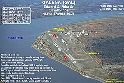
Galena Airport
|
Edward G. Pitka Sr. Airport (former Galena Air Force Base) |
|||||||||||||||
|---|---|---|---|---|---|---|---|---|---|---|---|---|---|---|---|
 |
|||||||||||||||
| Summary | |||||||||||||||
| Airport type | Public | ||||||||||||||
| Owner | State of Alaska DOT&PF - Northern Region | ||||||||||||||
| Serves | Galena, Alaska | ||||||||||||||
| Elevation AMSL | 153 ft / 47 m | ||||||||||||||
| Coordinates | 64°44′10″N 156°56′15″W / 64.73611°N 156.93750°WCoordinates: 64°44′10″N 156°56′15″W / 64.73611°N 156.93750°W | ||||||||||||||
| Map | |||||||||||||||
| Location of airport in Alaska | |||||||||||||||
| Runways | |||||||||||||||
|
|||||||||||||||
| Statistics (2014) | |||||||||||||||
|
|||||||||||||||
|
Source: Federal Aviation Administration
|
|||||||||||||||
| Aircraft operations | 19,000 |
|---|---|
| Based aircraft | 13 |
Edward G. Pitka Sr. Airport (IATA: GAL, ICAO: PAGA, FAA LID: GAL) is a state owned, public use airport located in Galena, a city in the Yukon-Koyukuk Census Area of the U.S. state of Alaska.
As per Federal Aviation Administration records, the airport had 7,784 passenger boardings (enplanements) in calendar year 2008, 7,447 enplanements in 2009, and 12,421 in 2010. It is included in the National Plan of Integrated Airport Systems for 2011–2015, which categorized it as a non-primary commercial service airport (between 2,500 and 10,000 enplanements per year) based on enplanements in 2008, however it qualifies as a primary commercial service airport based on enplanements in 2010.
As Galena Airport, it was used as a military transport base during World War II, facilitating the transit of Lend-Lease aircraft to the Soviet Union.
As Galena Air Force Station, it was used by the USAF during the Cold War as an interceptor base for aircraft patrolling the western areas of Alaska.
Edward G. Pitka Sr Airport covers an area of 1,250 acres (506 ha) at an elevation of 153 feet (47 m) above mean sea level. It has two runways: 7/25 is 7,249 by 150 feet (2,209 x 46 m) with an asphalt and concrete surface; 6/24 is 2,786 by 80 feet (849 x 24 m) with a gravel ski strip surface.
...
Wikipedia

