Gakona, Alaska
|
Gakona Ggax Kuna’ |
|
|---|---|
| CDP | |

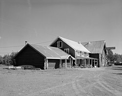
Side view of the Gakona Roadhouse, a major community building
|
|
 Location of Gakona, Alaska |
|
| Coordinates: 62°18′17″N 145°16′24″W / 62.30472°N 145.27333°WCoordinates: 62°18′17″N 145°16′24″W / 62.30472°N 145.27333°W | |
| Country | United States |
| State | Alaska |
| Census Area | Valdez-Cordova |
| Government | |
| • State senator | Click Bishop (R) |
| • State rep. | Dave Talerico (R) |
| Area | |
| • Total | 61.3 sq mi (158.9 km2) |
| • Land | 61.3 sq mi (158.9 km2) |
| • Water | 0 sq mi (0 km2) |
| Population (2010) | |
| • Total | 218 |
| Time zone | Alaska (AKST) (UTC-9) |
| • Summer (DST) | AKDT (UTC-8) |
| ZIP code | 99586 |
| Area code(s) | 907 |
| FIPS code | 02-27420 |
Gakona /ɡəˈkoʊnə/ (Ggax Kuna’ in Ahtna Athabascan) is a census-designated place (CDP) in the Valdez-Cordova Census Area in the U.S. state of Alaska. As of the 2010 census, the population of the CDP was 218.
Gakona is located at 62°18′17″N 145°16′24″W / 62.30472°N 145.27333°W (62.301940, -145.30194) (Sec. 18, T006N, R001E, Copper River Meridian). Gakona is located in the Chitina Recording District. Gakona is located in the center of Copper Valley, surrounded by mountains and the Copper River.
Gakona is at the confluence of the Copper and Gakona rivers, 15 miles (24 km) northeast of Glennallen. It lies at mile 2 on the Tok Cut-Off to the Glenn Highway, just east of the Richardson Highway. Gakona is located in the continental climate zone, with long, cold winters and relatively warm summers. Temperature extremes have been recorded from −62 to 91 °F (−52 to 33 °C). Snowfall averages 61 inches (150 cm), with total precipitation of 13 inches (330 mm) per year.
...
Wikipedia
