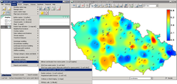
GRASS GIS
 |
|

GRASS graphical user interface
|
|
| Developer(s) | GRASS Development Team |
|---|---|
| Initial release | 1984 |
| Stable release |
7.0 / February 22, 2015
|
| Repository | grass |
| Development status | Active |
| Written in | C, C++, Python, Tcl |
| Operating system | Cross-platform |
| Available in | English, Czech, French, German, Italian, Japanese, Polish, Spanish, Vietnamese, ... |
| Type | Geographic information system |
| License | GNU General Public License |
| Website | grass |
Geographic Resources Analysis Support System (commonly termed GRASS GIS) is a geographic information system (GIS) software suite used for geospatial data management and analysis, image processing, producing graphics and maps, spatial and temporal modeling, and visualizing. It can handle raster, topological vector, image processing, and graphic data.
GRASS GIS contains over 350 modules to render maps and images on monitor and paper; manipulate raster and vector data including vector networks; process multispectral image data; and create, manage, and store spatial data.
It is licensed and released as free and open-source software under the GNU General Public License (GPL). It runs on multiple operating systems, including OS X, Windows and Linux. Users can interface with the software features through a graphical user interface (GUI) or by plugging into GRASS via other software such as QGIS. They can also interface with the modules directly through a bespoke shell that the application launches or by calling individual modules directly from a standard shell. The latest stable release version (LTS) is GRASS GIS 7, which is available since 2015
The GRASS Development Team is a multinational group consisting of developers at many locations. GRASS is one of the eight initial Software Projects of the Open Source Geospatial Foundation.
GRASS supports raster and vector data in two and three dimensions. The vector data model is topological, meaning that areas are defined by boundaries and centroids; boundaries cannot overlap within one layer. In contrast, OpenGIS Simple Features, defines vectors more freely, much as a non-georeferenced vector illustration program does.
...
Wikipedia
