GR10
| GR10 | |
|---|---|

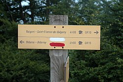
Signpost on the GR10
|
|
| Length | 866 km (538 mi) |
| Location | Pyrenees |
| Designation | GR footpath |
| Trailheads | Hendaye, Banyuls-sur-Mer |
| Use | Hiking |
| Elevation | |
| Elevation change | 48,000 m (157,000 ft) |
| Hiking details | |
| Season | late spring-early summer, late summer-early fall |
| Hazards | Storms, Snow, Heat |
The GR 10 is a French GR footpath, or hiking trail, that runs the length of the Pyrenees Mountains. It roughly parallels the French–Spanish border on the French side. Those attempting the entire trail often choose to walk it from west to east, from Hendaye on the Bay of Biscay to Banyuls-sur-Mer on the Mediterranean Sea, but it can just as easily be traversed east to west.
Hiking the entire route is estimated to take around 52 days for hikers who are in good shape and used to mountain hiking. Some stretches involve a lot of ascending and descending, including a few one-day sections that can climb and then descend 1,200 metres (3,900 ft), but the GR 10 is a hiking trail, and there is no actual mountain climbing involved. The trail covers a distance of 866 kilometres (538 mi), with 48,000 metres (157,000 ft) of ascent and given the coast to coast nature of the route the same descent.
There are many places to stay along the route that cater to walkers, including hotels, gîtes d'étape, and very basic mountain refuges. Camping is only necessary for two or three nights in the Ariège section. Some walkers walk one section of the trail at a time, completing the route over several visits.
The trail is well marked with red and white painted blazes. It appears on all regional maps, including on Michelin roadmaps. The route is within the area shown by the Editions Sud-Ouest Rando éditions range of maps (numbers 1–11), which are based on French Institut Géographique National 1:50,000 scale maps. Parts of the route, especially around towns and villages, change from year to year, so walkers do well to carry recent editions of the maps and guides.
A number of sections include alternative routes of a less demanding nature. Some alternatives offer more scenic choices, for example the alternative route from Cauterets to Luz-Saint-Sauveur takes in Pont d'Espagne, the Refuge Oulettes de Gaube, the Refuge Baysellance, Gavarnie, Gedre and Pragneres, and offers more spectacular mountain scenery.
...
Wikipedia
