Furnas do Bom Jesus State Park
| Furnas do Bom Jesus State Park | |
|---|---|
| Parque Estadual das Furnas do Bom Jesus | |
|
IUCN category II (national park)
|
|

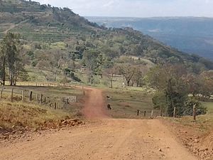
Hills in the park
|
|
| Nearest city | Pedregulho, São Paulo |
| Coordinates | 20°13′54″S 47°26′29″W / 20.231530°S 47.441276°WCoordinates: 20°13′54″S 47°26′29″W / 20.231530°S 47.441276°W |
| Area | 2,069 ha (7.99 sq mi) |
| Designation | State park |
| Created | 12 October 1989 |
| Administrator | Fundação Florestal - SP |
The Furnas do Bom Jesus State Park (Portuguese: Parque Estadual das Furnas do Bom Jesus) is a state park in the state of São Paulo, Brazil. It protects an area of cerrado and Atlantic Forest with high biodiversity in and around a canyon.
The Furnas do Bom Jesus State Park is in the municipality of Pedregulho, São Paulo, 442 kilometres (275 mi) from the state capital of São Paulo. The municipality is in the northeast of the state in the Ribeirão Preto mesoregion. It has an area of 2,069 hectares (5,110 acres), and is in the hydrographic basin of the Córrego do Pedregulho. .The terrain consists of medium hills with flat tops and slopes with small canyons. The name Furnas do Bom Jesus means "Caves of the Good Jesus", after the Bom Jesus canyon which leads through the park. Altitudes range from 300 to 1,073 metres (984 to 3,520 ft).
The Furnas do Bom Jesus State Park was created by state decree 30.591 of 12 October 1989. Decree 31.644 of 31 May 1990 declared the land as being of social interest for the purpose of expropriation. The park is a fully protected conservation unit with the objectives of preserving its ecosystems, geomorphological sites and natural landscapes, while supporting scientific research and public visits. Various universities use the park for scientific research, including the University of São Paulo.
The Köppen climate classification is Cwb Tropical Altitude, hot and humid in summer, cold and dry in winter. Temperatures vary from 18 to 32 °C (64 to 90 °F) in the summer and 3 to 13 °C (37 to 55 °F) in the winter, with average annual temperature from 21 to 25 °C (70 to 77 °F). The park protects an area with great biodiversity of native flora and fauna, including some species threatened with extinction.
Vegetation includes fragments of cerrado and Atlantic Forest seasonal semi-deciduous forest. There are cerradões, cerrado and meadows in the interfluvial areas, continuous gallery forest in the valley bottoms, including seasonal semi-deciduous forest and seasonal alluvial semi-deciduous forest, and seasonal deciduous forest on the slopes and walls of the canyons, particularly in places where there is the least water in the dry season. The natural cerrado vegetation on the top of the chapadas and the gentler slopes was almost entirely replaced by coffee plantations and pasturage, and is now regenerating. The areas that are harder to access have been little changed, preserving remnants of the original forest.
...
Wikipedia

