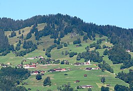
Furna
| Furna | ||
|---|---|---|
 |
||
|
||
| Coordinates: 46°56′N 9°40′E / 46.933°N 9.667°ECoordinates: 46°56′N 9°40′E / 46.933°N 9.667°E | ||
| Country | Switzerland | |
| Canton | Graubünden | |
| District | Prättigau/Davos | |
| Area | ||
| • Total | 33.32 km2 (12.86 sq mi) | |
| Elevation | 1,400 m (4,600 ft) | |
| Population (Dec 2015) | ||
| • Total | 209 | |
| • Density | 6.3/km2 (16/sq mi) | |
| Postal code | 7232 | |
| SFOS number | 3862 | |
| Surrounded by | Grüsch, Jenaz, Peist, St. Peter-Pagig, Schiers, Trimmis, Valzeina | |
| Website |
www SFSO statistics |
|
Furna is a municipality in the district of Prättigau/Davos in the Swiss canton of Graubünden.
Furna is first mentioned in 1479 as Furnen.
Furna has a population (as of 31 December 2015) of 209. As of 2008[update], 0.5% of the population was made up of foreign nationals. Over the last 10 years the population has grown at a rate of 0.5%. Most of the population (as of 2000[update]) speaks German (99.5%), with the rest speaking Norwegian ( 0.5%).
As of 2000[update], the gender distribution of the population was 49.3% male and 50.7% female. The age distribution, as of 2000[update], in Furna is; 34 children or 16.7% of the population are between 0 and 9 years old and 17 teenagers or 8.3% are between 10 and 19. Of the adult population, 24 people or 11.8% of the population are between 20 and 29 years old. 27 people or 13.2% are between 30 and 39, 24 people or 11.8% are between 40 and 49, and 22 people or 10.8% are between 50 and 59. The senior population distribution is 24 people or 11.8% of the population are between 60 and 69 years old, 26 people or 12.7% are between 70 and 79, there are 6 people or 2.9% who are between 80 and 89.
In the 2007 federal election the most popular party was the SVP which received 49.8% of the vote. The next three most popular parties were the FDP (23%), the local, small right-wing parties (13.8%) and the SP (13%).
...
Wikipedia


