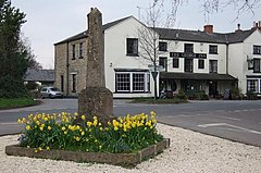
Frocester
| Frocester | |
|---|---|
 Village centre |
|
| Frocester shown within Gloucestershire | |
| Population | 155 |
| OS grid reference | SO7803 |
| Civil parish |
|
| District | |
| Shire county | |
| Region | |
| Country | England |
| Sovereign state | United Kingdom |
| Post town | Stonehouse |
| Postcode district | GL10 |
| Dialling code | 01453 |
| Police | Gloucestershire |
| Fire | Gloucestershire |
| Ambulance | South Western |
| EU Parliament | South West England |
| UK Parliament | |
Frocester (/ˈfrɒstər/ FROS-tər) is a village and civil parish in Stroud District, Gloucestershire, England. It lies below the Cotswold escarpment, 10 miles south of Gloucester and 4 miles west of Stroud. In the 2001 census the parish had a population of 194, decreasing to 155 at the 2011 Census.
Frocester was the site of a Roman settlement, on a Roman road which ran from Cirencester to Arlingham. The remains of a Roman villa have been excavated in the grounds of Frocester Court, and another near the remains of St Peters Church. The name of the village, first recorded in the Domesday Book as Frowecestre, means "Roman town on the Frome", although the River Frome is just beyond the present northern boundary of the parish.
In 1726 the line of the Roman road became a turnpike road, and formed part of the coaching route between Gloucester and Bath. Use of the road declined in the 19th century, and it is now a minor road.
Between 1844 and 1961, Frocester had a railway station on the Bristol and Gloucester Railway, later the Midland Railway.
...
Wikipedia

