Foyle (UK Parliament constituency)
| Foyle | |
|---|---|
|
County constituency for the House of Commons |
|

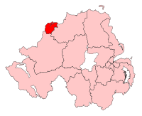
Boundary of Foyle in Northern Ireland 1995 – 2008.
|
|
| Districts of Northern Ireland | Derry City Council |
| Electorate | 68,565 (March 2011) |
| Current constituency | |
| Created | 1983 |
| Member of parliament | Mark Durkan (SDLP) |
| Number of members | One |
| Created from | Londonderry and Mid Ulster |
| Overlaps | |
| European Parliament constituency | Northern Ireland |
Coordinates: 55°01′34″N 7°23′46″W / 55.026°N 7.396°W
Foyle is a parliamentary constituency in the House of Commons of the United Kingdom. It has been represented since 2005 by Mark Durkan, of the Social Democratic and Labour Party.
1983-1997: The District of Londonderry, and the District of Strabane wards of Artigarvan, Dunnamanagh, East, North, Slievekirk, South, and West.
1997-2010: The District of Derry.
2010-present: The District of Derry wards of Altnagelvin, Ballynashallog, Beechwood, Brandywell, Carn Hill, Caw, Clondermot, Creggan Central, Creggan South, Crevagh, Culmore, Ebrington, Eglinton, Enagh, Foyle Springs, Holly Mount, Kilfennan, Lisnagelvin, New Buildings, Pennyburn, Rosemount, Shantallow East, Shantallow West, Springtown, Strand, The Diamond, Victoria, and Westland.
The seat was created in boundary changes in 1983, as part of an expansion of Northern Ireland's constituencies from 12 to 17, and was predominantly made up from the old Londonderry constituency. From further revisions in 1995 (when it lost parts of the district of Strabane to the West Tyrone constituency), and until the 2008 revision, it covered exactly the same area as Derry city.
The name comes from the River Foyle which the city lies on and is used to avoid the contentious names of Derry or Londonderry, as well as to cover the areas of County Tyrone that were originally in the constituency.
...
Wikipedia
