Fort Vrmac
| Fort Vrmac | |
|---|---|
| Tvrđava Vrmac / Werk Vermac | |
| near Tivat, Montenegro | |

View of the entrance and north caponier of Fort Vrmac
|
|
| Coordinates | 42°25′16″N 18°44′57″E / 42.421053°N 18.749236°E |
| Type | Fortification |
| Site information | |
| Controlled by | Montenegro |
| Condition | Abandoned |
| Site history | |
| Built | 1860 (first fortress), 1894–7 (current structure) |
| Built by | Austro-Hungarian Empire |
| In use | 1860–1918, 1918–? |
| Materials | Concrete, limestone |
| Battles/wars | First World War |
| Garrison information | |
| Garrison | 5 officers & 177 men (wartime numbers) |
Fort Vrmac (Montenegrin: Tvrđava Vrmac/Тврђава Врмац, German: Werk Vermac) is a former fortification of the Austro-Hungarian Empire located on the southern end of the Vrmac ridge near Tivat in Montenegro. Established in 1860, the present structure was built between 1894 and 1897, and saw action during the First World War, when it was heavily bombarded by the Montenegrins. It was repaired and disarmed before the end of the war and was abandoned after a period of occupation by Yugoslav troops. Today it is one of the best preserved Austro-Hungarian fortifications in the Bay of Kotor area.
The southernmost tip of the Austro-Hungarian Empire included the area of the Bay of Kotor, which was used by the empire as a major naval base centred on the town of Kotor (known then as Cattaro). The hinterland behind the bay was controlled by the independent principality (later kingdom) of Montenegro, which controlled the mountains to the east of Kotor.
The Austro-Hungarians faced significant problems in holding on to the territory, as the Montenegrins and their Russian allies aspired to take control of the Bay and Austrian rule was not universally accepted by the area's inhabitants. Two serious rebellions were mounted by the powerful Krivošije clan who lived on the eastern flanks of Mount Orjen above Risan. In 1869 the clan defeated an Austro-Hungarian force sent to quell their rebellion, but Austrian control was reimposed in 1882. The Austrians responded to the uprising by building a series of fortifications around the Bay of Kotor and at strategic points further inland, and strengthening existing fort, including the one at Vrmac.
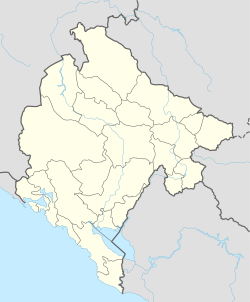
Fort Vrmac is situated on Vrmac, a limestone ridge that rises to 759 metres (2,490 ft) and divides the inner and outer part of the Bay of Kotor. It overlooks Kotor to the east, the Troica pass leading to Kotor to the south, and the Župa valley to the west. The fort is reached via a military road built by the Austro-Hungarians that runs over the top of the ridge from Troica to Gornja Lastva in Tivat municipality, or alternatively via a winding path that leads up the mountainside from Muo, a suburb of Kotor. Its position was chosen to enable it to support the outlying Fort Gorazda on the other side of the Troica pass and the Škaljari Battery to the south. From 1909, it was also supported by Fort Trašte located on the hills above the plain of Tivaksko polje to the west. The location is highly strategic but was vulnerable to artillery attack from the heights of Mount Lovćen on the other side of the Bay of Kotor.
...
Wikipedia

