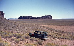
Fort Rock Valley
| Fort Rock-Christmas Lake Valley Basin | |
|---|---|

Fort Rock and its basin
|
|
| Location | Lake County, Oregon, USA |
| Coordinates | 43°18′N 121°00′W / 43.3°N 121°WCoordinates: 43°18′N 121°00′W / 43.3°N 121°W |
| Elevation | 4,331–5,630 ft (1,320–1,716 m) |
| Geology | maar field |
| Age | About 50,000 to 100,000 years old |
| Last eruption | About 50,000 years ago |
| Paleolake Fort Rock | |
|---|---|
| Location | Oregon |
| Type | Endorheic pluvial lake |
| Surface area | 2,300 kilometres (1,400 mi)2 |
| Max. depth | 75 metres (246 ft) |
| Surface elevation | 1,384 metres (4,541 ft) |
The Fort Rock-Christmas Lake Valley Basin is the basin of a former inland sea that existed in that region from Pliocene through late time. The Fort Rock basin maar field includes over 30 hydrovolcanic landforms spread over an area of 1,500 square miles (4,000 km2). During the Pleistocene and early Holocene, Paleolake Fort Rock encompassed the entire basin.
The Fort Rock Basin is a endorheic basin. Increased moisture in this semiarid environment during the through increased cloud cover and cooler temperatures resulted in higher lake levels. At its maximum, the lake filled the basin up to 75 m deep (245ft), with a surface area of over 2,300 km2 (900 mi2). While this is larger than any modern lakes in Oregon, Paleolake Fort Rock was smaller than any of the other paleolakes to the south.
There are four major shorelines of Fort Rock Basin from the paleolake. These shorelines are identified through recording wave-cut and depositional terraces, lagoons, and convex sedimentary deposits such as bars, spits, and beach ridges. The floor of the Fort Rock Basin is relatively flat at around 1,315 m (4,315 ft) throughout much of the basin, so the depths of the lake at each level were fairly consistent.
The highest shoreline at 1,384 m (4,540 ft) is best seen at Fandango Canyon, but traces of beach sediments and wave-washed scarps have also been identified at Cougar Mountain and the southern end of the Connley Hills. The lake had an average depth of 70 meters (230 feet), with a maximum depth of 76 meters (250 feet) at the eastern edge of the basin. The Connley Hills and Buchgrass Butte formed two major islands.
The next shoreline at 1,364-67 m (4,475-85 ft) is seen at only a few places in the Fort Rock Basin, such as Fandango Canyon and Cougar Mountain. This level formed the caves at the top of the southern toe of the Connley Hills. The lake was 52 meters (170 feet) deep at this level and covered an area of 1,945 km2 (1208 mi2). The only islands exposed were the Connely Hills, Buchgrass Butte, and the Fort Rock tuff ring.
The 1,353-1356 m (4,440-4450 ft) shoreline is the most strongly developed, as it carved the notches in Fort Rock and the caves in the Connley Hills and Cougar Mountain. The lake was, on average, 38 meters (125 feet) deep and covered 1736km2 (1078 mi2).
...
Wikipedia

