Fort Necessity
| Fort Necessity National Battlefield | |
| National Battlefield | |
|
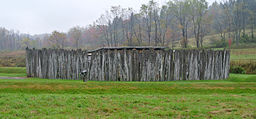
The reconstructed Fort Necessity.
|
|
| Country | United States |
|---|---|
| State | Pennsylvania |
| County | Fayette |
| Township | Wharton Township |
| Elevation | 1,955 ft (595.9 m) |
| Coordinates | 39°48′55″N 79°35′22″W / 39.81528°N 79.58944°WCoordinates: 39°48′55″N 79°35′22″W / 39.81528°N 79.58944°W |
| Area | 902.8 acres (365.4 ha) |
| Established | 1931-03-04 |
| - Transferred to NPS | 1933-08-10 |
| Owner | National Park Service |
| Nearest city | Uniontown, Pennsylvania |
|
Website: www |
|
|
Fort Necessity National Battlefield
|
|
| Nearest city | Uniontown |
| NRHP Reference # | 66000664 |
| Added to NRHP | October 15, 1966 |
Fort Necessity National Battlefield is a National Battlefield Site in Fayette County, Pennsylvania, United States, which preserves the site of the Battle of Fort Necessity. The battle, which took place on July 3, 1754, was an early battle of the French and Indian War, and resulted in the surrender of British colonial forces under Colonel George Washington, to the French and Indians, under Louis Coulon de Villiers.
The site also includes the Mount Washington Tavern, once one of the inns along the National Road, and in two separate units the grave of the British General Edward Braddock, killed in 1755, and the site of the Battle of Jumonville Glen.
After returning to the great meadows in what is now Fayette County, Pennsylvania, George Washington decided it prudent to reinforce his position. Supposedly named by Washington as Fort Necessity or Fort of Necessity, the structure protected a storehouse for supplies such as gunpowder, rum, and flour. The crude palisade they erected was built more to defend supplies in the fort's storehouse from Washington's own men, whom he described as "loose and idle", than as a planned defense against a hostile enemy. The sutler of Washington's force was John Fraser, who earlier had been second-in-command at Fort Prince George. Later he served as Chief Scout to General Edward Braddock and then Chief Teamster to the Forbes Expedition.
By June 13, 1754, Washington had under his command 295 colonials and the nominal command of 100 additional regular British army troops from South Carolina. Washington spent the remainder of June 1754 extending the wilderness road further west and down the western slopes of the Allegheny range into the valley of the Monongahela River. He wanted to create a river crossing point roughly 41 mi (66 km) near Redstone Creek and Redstone Old Fort. This was a prehistoric Native American earthwork mound on a bluff overlooking the river crossing. The aboriginal mound structure may have once been part of a fortification. Five years later in the war, Fort Burd was constructed at Redstone Old Fort. The area eventually became the site of Nemacolin Castle and Brownsville, Pennsylvania—an important western jumping-off point for travelers crossing the Alleghenies in the late 18th and early 19th centuries.
...
Wikipedia


