Fort Hill, Boston
|
Fort Hill or the Roxbury Highlands Historic District
|
|

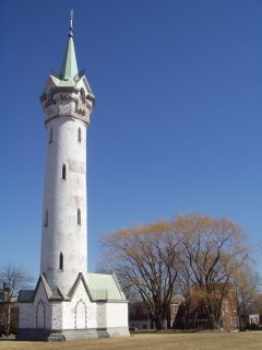
Fort Hill's name originates from the American Revolutionary War fortification built in the center of the district, now the location of the Cochituate Standpipe.
|
|
| Location | Boston, Massachusetts |
|---|---|
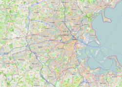
| Coordinates | 42°19′31″N 71°5′40″W / 42.32528°N 71.09444°WCoordinates: 42°19′31″N 71°5′40″W / 42.32528°N 71.09444°W |
| NRHP Reference # | |
| Added to NRHP | February 22, 1989 |
Fort Hill is a 0.4 square mile neighborhood and historic district of Roxbury, in Boston, Massachusetts. The approximate boundaries of Fort Hill are Malcolm X Boulevard on the north, Washington Street on the southeast, and Columbus Avenue on the southwest.
The geographic area comprising Fort Hill was strategically important during the American Revolutionary War and housed the patriot army defenses during the Siege of Boston. Fort Hill is actually named after an earthwork fortification that the patriot army built upon the hill located at the center of the neighborhood. The hill is now the location of Highland Park, which is notable for a Victorian-era tower designed by Nathaniel Jeremiah Bradlee, and landscaping designed by Frederick Law Olmsted.
Fort Hill developed rapidly as a residential neighborhood in the 19th century, especially after the extension of streetcar service from Boston. Fort Hill is served by the Massachusetts Bay Transportation Authority's Orange and Silver Lines. The neighborhood features a variety of architecture including Greek Revival and Italiantate houses that predate the American Civil War, classic Boston triple-deckers, row houses and newer green developments. The neighborhood of Fort Hill, which is sometimes referred to as Highland Park, was listed on the National Register of Historic Places as the Roxbury Highlands Historic District on February 22, 1989.
...
Wikipedia


