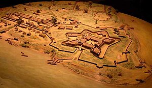
Fort Du Quesne
| Fort Duquesne | |
|---|---|
| Pittsburgh, Pennsylvania | |
 |
|
| Type | Fort |
| Site information | |
| Controlled by |
|
| Site history | |
| Built | 1754 |
| In use | 1754–1758 |
| Battles/wars | French and Indian War |
| Designated | May 8, 1959 |
Fort Duquesne (/duːˈkeɪn/, French: [dyken]; originally called Fort Du Quesne) was a fort established by the French in 1754, at the convergence point of the Allegheny and Monongahela rivers in what is now downtown Pittsburgh in the U.S. state of Pennsylvania.
It was destroyed by the French, prior to an English Invasion, and replaced by Fort Pitt in 1758. The site of both forts is now occupied by Point State Park, where the outlines of the two forts have been laid in brick.
Fort Duquesne, built at a point where the Allegheny and Monongahela rivers came together to form the Ohio River, was long seen as important for controlling the Ohio Country, both for settlement and for trade. Englishman William Trent had established a highly successful trading post at the forks as early as the 1740s, to do business with a number of nearby Native American villages. Both the French and the British were keen to gain advantage in the area. As the area was within the drainage basin of the Mississippi River, the French claimed it as theirs.
In the early 1750s, the French commenced construction of a line of forts, starting with Fort Presque Isle on Lake Erie near present-day Erie, Pennsylvania, followed by Fort Le Boeuf, about 15 miles inland near present-day Waterford, and Fort Machault, on the Allegheny River in Venango County in present-day Franklin.
...
Wikipedia
