Forest Highway 35
| Portage Glacier Highway | |
|---|---|
| Whittier Access Road | |

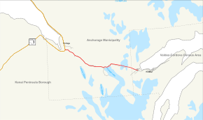
Portage Glacier Highway highlighted in red
|
|
| Route information | |
| Maintained by Alaska DOT&PF | |
| Length: | 11.59 mi (18.65 km) |
| Existed: | June 7, 2000 – present |
| Major junctions | |
| West end: |
|
| East end: |
|
| Location | |
| Boroughs: | Municipality of Anchorage, Unorganized |
| Highway system | |
| Forest Highway 35 | |
|---|---|
| Location: | Chugach National Forest |
| Length: | 6.59 mi (10.61 km) |
The Portage Glacier Highway, or Portage Glacier Road, is a highway located in the U.S. state of Alaska. The highway is made up of a series of roads, bridges, and tunnels that connect the Portage Glacier area of the Chugach National Forest and the city of Whittier to the Seward Highway. Most of the highway travels through mainly rural areas just north of the Kenai Peninsula, with the Anton Anderson Memorial Tunnel passing under Maynard Mountain, part of the Chugach Mountain Range. Parts of the route were first constructed in the early 1900s, and the entire highway was completed on June 7, 2000, as part of the Whittier Access Project. As of 2012[update], the highway has not been extended or rerouted. The main portion of the highway traveling from the western terminus to the Begich, Boggs visitors center is designated as National Forest Highway 35 by the U.S. Forest Service.
The portion of the Portage Glacier Highway traveling from the Seward Highway to the Begich, Boggs Visitor Center is designated as part of Forest Highway 35, a Federal Forest Highway (FFH). Forest Highways are funded and administered by the US Forest Service and the Federal Highway Administration; the system was created by the Federal Aid Highway Act of 1921. FFH-35 is one of the 33 Forest Highways that are currently designated in Alaska.
The Portage Glacier Highway begins at an at-grade intersection with the Seward Highway, in the former town of Portage. At this point, the highway is a two-lane, asphalt road. Almost immediately after the Seward Highway intersection, the road crosses over the Coastal Classic line of the Alaska Railroad. The highway continues in a southeasterly direction along the Portage Valley, with Portage Creek to the north and pine forests to the south. After about 1.2 miles (1.9 km), the roadway intersects a small gravel road that leads to the Moose Flats Day Use area, which has access to several scenic hiking trails. Peaks of the Chugach Mountains, along with several hanging glaciers can be seen from the road; Portage Glacier itself is out of view. The highway passes through a low-lying wetland before reentering forest and providing access to the Alder Pond Day Use area and the Portage Valley RV park.
...
Wikipedia
