Florida Keys Scenic Highway
| Overseas Highway | |
|---|---|

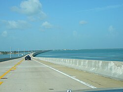
Overseas Highway traversing the Seven Mile Bridge
|
|
| Carries |
|
| Crosses | Gulf of Mexico, Florida Strait |
| Locale | Florida Keys |
| Maintained by | FDOT |
| Heritage status | NRHP (1979) |
| Preceded by | Overseas Railroad |
| Characteristics | |
| Total length | 113 miles (182 km) |
| Longest span | 6.79 miles (10.93 km) |
| Clearance above | 65 feet (20 m) (at Moser Channel) |
| History | |
| Designer | Florida East Coast Railway; Overseas Highway & Toll Bridge Commission |
| Constructed by | Henry Flagler |
| Opened | March 29, 1938 |
The Overseas Highway is a 113-mile (181.9 km) highway carrying U.S. Route 1 (US 1) through the Florida Keys. Large parts of it were built on the former right-of-way of the Overseas Railroad, the Key West Extension of the Florida East Coast Railway. Completed in 1912, the Overseas Railroad was heavily damaged and partially destroyed in the Labor Day Hurricane of 1935. The Florida East Coast Railway was financially unable to rebuild the destroyed sections, so the roadbed and remaining bridges were sold to the state of Florida for $640,000.
Since the 1950s the Overseas Highway has been refurbished into a main coastal highway between the cities of Miami and Key West, offering travelers an exotic roadway through a tropical savanna environment and access to the largest area of coral reefs on the U.S. mainland. Many exotic animals such as the American Crocodile and Key Deer inhabit the tropical islands of the Florida Keys.
While the Overseas Highway today runs along the former Overseas Railroad right of way, portions of the highway came into existence earlier in a different alignment while the railroad was still operational. The concept of an Overseas Highway began with the Miami Motor Club in 1921. The Florida land boom of the 1920s was underway and the club wanted to attract tourists to easily reached fishing areas, which could only be reached by boat or train at the time. The land boom also attracted real estate interests who sought vehicular access to the upper keys where there were thousands of acres of undeveloped land. The completion of the railroad further proved a highway through the keys was feasible.
Construction on the original Overseas Highway, designated State Road 4A (an extension of a route running from Miami to Homestead), lasted through most of the mid 1920s. Officially opening for traffic on January 25, 1928, the original highway existed in two segments at its greatest extent. One segment ran from the mainland via Card Sound Road to Key Largo and extended as far as Lower Matecumbe Key, while a segment in the lower keys existed from No Name Key to Key West. An automobile ferry service connected the 41 mile gap between Lower Matecumbe and No Name Keys. State Road 4A mostly ran alongside of the Overseas Railroad in the upper keys but in the lower keys, it followed a much different path than the railroad and current highway. The ferry landing on No Name Key was located at the end of what is now Watson Boulevard, which carried State Road 4A across No Name Key and Big Pine Key before it crossed to Little Torch Key. On Little Torch Key, it turned south and rejoined the railroad. It would continue along the north side of the railroad to Upper Sugarloaf Key, where it turned south and ran along the current route of County Roads 939 and 939A over Lower Sugarloaf Key and the Saddlebunch Keys. From the Saddlebunch Keys, State Road 4A crossed onto Geiger Key, continuing along what is now Geiger Road and Boca Chica Road. On Boca Chica Key, it followed the shoreline south of Naval Air Station Key West's airstrip to Boca Chica Beach before crossing to Stock Island. On Stock Island, it followed Maloney Avenue and MacDonald Avenue where it rejoined the Overseas Railroad heading into Key West. Most of the State Road 4A bridges in the Lower Keys were of wooden construction and had been in use by the early 1920s.
...
Wikipedia
