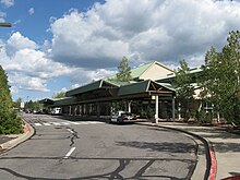
Flagstaff Pulliam Airport
| Flagstaff Pulliam Airport | |||||||||||
|---|---|---|---|---|---|---|---|---|---|---|---|
 |
|||||||||||

Main terminal
|
|||||||||||
| Summary | |||||||||||
| Airport type | Public | ||||||||||
| Owner | City of Flagstaff | ||||||||||
| Serves | Flagstaff, Arizona | ||||||||||
| Elevation AMSL | 7,014 ft / 2,138 m | ||||||||||
| Coordinates | 35°08′25″N 111°40′09″W / 35.14028°N 111.66917°WCoordinates: 35°08′25″N 111°40′09″W / 35.14028°N 111.66917°W | ||||||||||
| Website | Flagstaff.AZ.gov/... | ||||||||||
| Map | |||||||||||
| Location in Arizona | |||||||||||
| Runways | |||||||||||
|
|||||||||||
| Statistics (2011) | |||||||||||
|
|||||||||||
|
Source: Federal Aviation Administration
|
|||||||||||
| Aircraft operations | 33,207 |
|---|---|
| Based aircraft | 135 |
Flagstaff Pulliam Airport (IATA: FLG, ICAO: KFLG, FAA LID: FLG) is five miles south of Flagstaff, in Coconino County, Arizona. The airport is serviced by one airline, American Eagle, and is also used for general aviation. Federal Aviation Administration records say the airport had 51,765 passenger boardings (enplanements) in calendar year 2008, 66,627 in 2009 and 62,109 in 2010. The National Plan of Integrated Airport Systems for 2011–2015 called it a "primary commercial service" airport (more than 10,000 enplanements per year).
The airport covers 795 acres (322 ha) at an elevation of 7,014 feet (2,138 m). Its one runway, 3/21, is 8,800 by 150 feet (2,682 x 46 m) asphalt.
In the year ending April 30, 2011 the airport had 33,207 aircraft operations, average 90 per day: 70% general aviation, 26% air taxi, 3% military, and 1% airline. 135 aircraft were then based at the airport: 85% single-engine, 11% multi-engine, 3% helicopter, and 2% ultralight.
Presidential candidate and U.S. Senator John McCain's Boeing 737 campaign aircraft visited Flagstaff prior to the 2008 election.
Historically, Flagstaff was served by the Frontier Airlines until 1979 with Convair 580 turboprops to Phoenix as well as direct, no change of plane CV-580 service to Denver via Gallup, NM, Farmington, NM and Durango, CO.
...
Wikipedia

