Fisherton de la Mere
| Fisherton Delamere | |
|---|---|
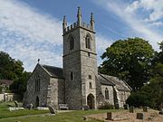
 St Nicholas's Church, Fisherton |
|
| Fisherton Delamere shown within Wiltshire | |
| OS grid reference | SU000385 |
| Civil parish | |
| Unitary authority | |
| Ceremonial county | |
| Region | |
| Country | England |
| Sovereign state | United Kingdom |
| Post town | Warminster |
| Postcode district | BA12 |
| Dialling code | 01985 |
| Police | Wiltshire |
| Fire | Dorset and Wiltshire |
| Ambulance | South Western |
| EU Parliament | South West England |
| UK Parliament | |
Fisherton Delamere, also spelt Fisherton de la Mere and Fisherton Delamare, is a small village and former civil parish on the River Wylye, Wiltshire, England.
The parish came to an end in 1934 and was divided between Wylye and , the latter gaining the hamlet of Bapton, while the village of Fisherton Delamere retained a separate identity within Wylye.
The settlement lies just off the A36 road, midway between Salisbury and Warminster, and some ten miles south-west of Amesbury.
Position: grid reference SU001385
In the Domesday Book of 1086, Fisherton is spelt Fisertone and had not yet gained its further name. "Delamere", variously spelt through the ages, was added later because this was the name of the lords of the manor, the Delameres of Nunney Castle.
In 1086, Fisherton was owned by Roger de Corcelle. He was also the owner of Curry Mallet in Somerset, under which his Wiltshire manor was held. In the time of Edward the Confessor, Fisherton had been owned by a man named Bondi.
The ancient parish of Fisherton Delamere formed a detached part of the Warminster hundred of Wiltshire. It contained two villages, Fisherton itself, to the north of the River Wylye, and Bapton, about a mile away and to the south of the river, and a combined total of 2,834 acres, of which 1,660 were in Fisherton. The civil parish, was extinguished in 1934, when Fisherton was transferred to Wylye, and Bapton to . The former parish was a rough oblong stretching both north and south up into the downland on each side of the river, each slope running down from an altitude of about 600 feet. At the south is a level area called the Bake. On the north-east the parish boundary ran along the old road from Chitterne to Stapleford, on the south along Grim's Dyke, an ancient earthwork, while on the south-west the boundary cut through a combe, Roakham Bottom.
...
Wikipedia

