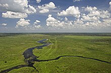
Fisheating Creek
| Fisheating Creek | |
|---|---|

Aerial view
|
|
| Country | United States |
| Basin features | |
| Main source | Near Lake Placid, Florida |
| River mouth | Fisheating Bay, Lake Okeechobee |
| Physical characteristics | |
| Length | 40 to 51 miles (64 to 82 km) |
Fisheating Creek is a stream that flows into Lake Okeechobee in Florida. It is the only remaining free-flowing water course feeding into the lake, and the second-largest natural source for the lake. Most of the land surrounding the stream is either publicly owned or under conservation easements restricting development. The lower part of the stream remains in a largely natural state, and efforts are underway to restore the upper part of the stream to a more natural state.
The name Fisheating Creek is derived from the Seminole name for the stream, Thlothlopopka-Hatchee, which is translated as "the river where fish are eaten". Fisheating Creek is between 40 miles (64 km) and 51 miles (82 km) long. It flows southward through an area called the Cypress Swamp in the southwestern part of Highlands County and into Glades County, where it turns eastward about 1 mile (1.6 km) north of County Road 731 and flows about 30 miles (48 km) to Lake Okeechobee. The stream spreads out into Cowbone Marsh for the last 8 miles (13 km) before entering the lake. Fisheating Creek is the second-largest natural source of water for Lake Okeechobee (behind the Kissimmee River), supplying close to 9% of the water flowing into the lake.
Fisheating Creek originally arose in a series of perennial marshes in Highlands County west of Lake Placid. Each marsh overflowed into another, slightly lower marsh until Fisheating Creek emerged. In the 20th century ditches and a canal drained the marshes, which were converted into agricultural land. In 2010 the United States Department of Agriculture purchased a conservation easement on 26,000 acres (110 km2) in Highlands County south of State Road 70, and plans to restore the land in the easement area to marshes.
Fisheating Creek flows through a landscape of prairies, both dry and wet, flatwoods, freshwater marshes, hammocks, bottomland forests, and floodplain swamps. Human activity has introduced improved pastures, and eucalyptus and pine plantations. In 1842 Fisheating Creek was described as a large stream in the dry season, varying in width from a river to a brook, and very "tortuous". Lake Okeechobee has been artificially maintained at a lower level than prevailed before the 20th century, with the result that much of Cowbone Marsh has been drained and converted to agricultural land. Lake Okeechobee has been almost completely enclosed by the Herbert Hoover Dike. The only gap in the dike is at Fisheating Creek, where the dike turns inland and parallels the stream on both sides for several miles, leaving Fisheating Creek as the only remaining free-flowing tributary of Lake Okeechobee. The Lake Okeechobee Scenic Trail runs across the Herbert Hoover Dike.
...
Wikipedia
