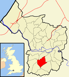
Filwood (ward)
| Filwood | |
|---|---|
 Boundaries of the city council ward. |
|
| Filwood shown within Bristol | |
| Population | 12,267 (2011.Ward) |
| OS grid reference | ST594698 |
| Unitary authority | |
| Ceremonial county | |
| Region | |
| Country | England |
| Sovereign state | United Kingdom |
| Post town | BRISTOL |
| Postcode district | BS4 |
| Dialling code | 0117 |
| Police | Avon and Somerset |
| Fire | Avon |
| Ambulance | South Western |
| EU Parliament | South West England |
| UK Parliament | |
Filwood is a council ward of the city of Bristol in the United Kingdom. It lies in the south of the city and covers the suburbs of Filwood Park, Lower Knowle and Inns Court.
Filwood Park is a primarily residential area of Bristol. It has a number of primary schools.
Lower Knowle is a part of the Knowle area of Bristol that lies within the Filwood ward.
Inns Court, sometimes spelled Inn's Court, is an area of south Bristol that lies within the Filwood council ward. It contains a bus depot belonging to FirstGroup.
...
Wikipedia
