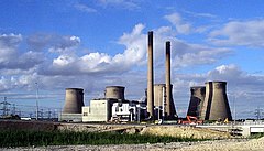
Ferrybridge
Ferrybridge
|
|
|---|---|
 Ferrybridge C Power Station |
|
| Ferrybridge shown within West Yorkshire | |
| Population | 1,491 (2001) |
| OS grid reference | SE475245 |
| Metropolitan borough | |
| Metropolitan county | |
| Region | |
| Country | England |
| Sovereign state | United Kingdom |
| Post town | KNOTTINGLEY |
| Postcode district | WF11 |
| Dialling code | 01977 |
| Police | West Yorkshire |
| Fire | West Yorkshire |
| Ambulance | Yorkshire |
| EU Parliament | Yorkshire and the Humber |
| UK Parliament | |
Ferrybridge is a village in West Yorkshire, England. Ferrybridge lies at a historically important crossing of the River Aire which borders the North Yorkshire village of Brotherton. It is linked to other communities by the A1, which follows the route of the Great North Road. The village falls within the Knottingley ward of Wakefield City Council.
The origin of the place-name is from Old Norse and means bridge by the ferry. It appears as Ferie in the Domesday Book of 1086 and as Ferybrig in 1198.
Geologically, Ferrybridge and Knottingley are located on rich soil, over a bed of magnesian limestone.
The area is close to junctions of the M62 and A1(M) motorways; as well as junctions on the rail network, including northward to York, south to Pontefract (and Rotherham), west to both Wakefield and Leeds, east to Goole and south-east to the ECML; the River Aire meets the Aire and Calder navigation close to the east of the town.
The area is famous for the power station and the M62 services which offers a Burger King, an M&S Simply Food, a Cotton Traders, a WH Smiths, a Greggs, and a Travelodge.
Ferrybridge Power Station to the north dominates the skyline around the village.
The village has two public houses; "The Golden Lion" which sits by Ferrybridge lock and is steeped in colourful history during its time as a coaching Inn and "The Magnet Inn".
...
Wikipedia

