Fermanagh Township, Juniata County, Pennsylvania
| Fermanagh Township, Pennsylvania |
|
|---|---|
| Township | |

A road cut along U.S. Route 322 with visible anticline rock strata
|
|
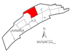
 Map of Juniata County, Pennsylvania highlighting Fermanagh Township |
|
 Map of Juniata County, Pennsylvania |
|
| Country | United States |
| State | Pennsylvania |
| County | Juniata |
| Settled | 1754 |
| Incorporated | 1755 |
| Area | |
| • Total | 32.5 sq mi (84.1 km2) |
| • Land | 32.1 sq mi (83.1 km2) |
| • Water | 0.4 sq mi (1.0 km2) |
| Population (2000) | |
| • Total | 2,544 |
| • Density | 79.2/sq mi (30.6/km2) |
| Time zone | EST (UTC-5) |
| • Summer (DST) | EDT (UTC-4) |
| Area code(s) | 717 |
Fermanagh Township is a township in Juniata County, Pennsylvania, United States. The population was 2,544 at the 2000 census.
It was named after County Fermanagh in Ireland.
According to the United States Census Bureau, the township has a total area of 32.5 square miles (84 km2), of which, 32.1 square miles (83 km2) of it is land and 0.4 square miles (1.0 km2) of it (1.17%) is water.
Fermanagh Township is bordered by Mifflin County to the north, Fayette Township to the east and Walker Township to the south. The Juniata River forms the western and souther borders with Milford Township. The borough of Mifflintown lies along the river in the southwestern corner of the township.
As of the census of 2000, there were 2,544 people, 971 households, and 728 families residing in the township. The population density was 79.2 people per square mile (30.6/km²). There were 1,098 housing units at an average density of 34.2/sq mi (13.2/km²). The racial makeup of the township was 98.86% White, 0.31% African American, 0.63% Asian, and 0.20% from two or more races. Hispanic or Latino of any race were 0.55% of the population.
...
Wikipedia
