Fenway-Kenmore
| Fenway–Kenmore | |
|---|---|
| Neighborhood in Boston | |

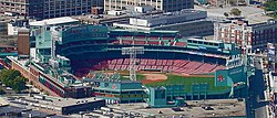
Fenway Park, home of the Boston Red Sox, is located in the Fenway–Kenmore neighborhood
|
|
| Coordinates: 42°20′31.39″N 71°06′00.91″W / 42.3420528°N 71.1002528°WCoordinates: 42°20′31.39″N 71°06′00.91″W / 42.3420528°N 71.1002528°W | |
| Country | United States |
| State | Massachusetts |
| County | Suffolk |
| City | Boston |
| Area | |
| • Total | 1.24 sq mi (3.2 km2) |
| Population (2010) | 40,898 |
| • Density | 32,982.3/sq mi (12,734.5/km2) |
| Time zone | Eastern (UTC-5) |
| ZIP code(s) | 02115, 02215 |
| Area code(s) | 617, 857 |
Fenway–Kenmore is an officially recognized neighborhood of Boston, Massachusetts. While it is considered one neighborhood for administrative purposes, it is composed of numerous distinct sections (East Fenway, West Fenway, Audubon Circle, Kenmore Square) that, in casual conversation, are almost always referred to as "the Fenway," "Kenmore Square," or "Kenmore." Furthermore, the Fenway neighborhood is divided into two sub-neighborhoods commonly referred to as East Fenway/Symphony and West Fenway.
Fenway is named after the Fenway, the main thoroughfare, laid out by Frederick Law Olmsted. As of the 2010 Boston Redevelopment Authority Census, Fenway–Kenmore's population was 40,898, while its land area was defined to be 1.24 square miles (3.2 km2).
On the east, Fenway–Kenmore is separated from the Back Bay neighborhood by Charlesgate West, the Massachusetts Turnpike, Dalton Avenue and Belvidere Street. The South End is across Huntington Avenue near The First Church of Christ, Scientist headquarters, a major tourist attraction. East Fenway (generally south of the Massachusetts Turnpike) is separated from West Fenway by the Muddy River, which flows through the Back Bay Fens and into the Charles River north of Kenmore.
Across the southwestern corner includes the Longwood Medical Area down to St. Francis, Tremont, and St. Alphonsus Streets. To the south is the Mission Hill, part of the formerly independent city of Roxbury, which continues as the border extends along Ward, Parker, and Ruggles Streets, and the Southwest Corridor. Across St. Mary Street from West Fenway is the neighboring town of Brookline. The Kenmore neighborhood is located north and west of Fenway, roughly separated by the Massachusetts Turnpike. On the narrow strip of land between Brookline at Commonwealth Avenue and the Charles River, Kenmore extends to the Boston University Bridge, where it meets Allston-Brighton.
...
Wikipedia
