Fedje (village)
| Fedje | |
|---|---|
| Village | |

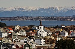
View of the village
|
|
| Location in Hordaland county | |
| Coordinates: 60°46′44″N 04°42′53″E / 60.77889°N 4.71472°ECoordinates: 60°46′44″N 04°42′53″E / 60.77889°N 4.71472°E | |
| Country | Norway |
| Region | Western Norway |
| County | Hordaland |
| District | Nordhordland |
| Municipality | Fedje |
| Area | |
| • Total | 0.68 km2 (0.26 sq mi) |
| Elevation | 14 m (46 ft) |
| Population (2013) | |
| • Total | 429 |
| • Density | 631/km2 (1,630/sq mi) |
| Time zone | CET (UTC+01:00) |
| • Summer (DST) | CEST (UTC+02:00) |
| Post Code | 5947 Fedje |
Fedje is the administrative centre of Fedje municipality in Hordaland county, Norway. The village is located on the northern shores of the island of Fedje. The fishing village is an old trading center, which grew up around Kræmmerholmen, a small island in the Fedje harbor. The 0.68-square-kilometre (170-acre) village has a population (2013) of 429, giving the village a population density of 631 inhabitants per square kilometre (1,630/sq mi).Fedje Church is located in the village, serving the people of the whole municipality.
...
Wikipedia


