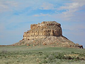
Fajada Butte
| Fajada Butte | |
|---|---|

Fajada Butte mid-morning
|
|
| Highest point | |
| Elevation | 6,623 ft (2,019 m) NGVD 29 |
| Coordinates | 36°01′08″N 107°54′35″W / 36.0189052°N 107.9097837°WCoordinates: 36°01′08″N 107°54′35″W / 36.0189052°N 107.9097837°W |
| Geography | |
| Location | San Juan County, New Mexico, U.S. |
| Topo map | USGS Pueblo Bonito |
| Geology | |
| Age of rock | Cretaceous |
| Mountain type | Sandstone |
| Climbing | |
| First ascent | circa 850 AD |
| Easiest route | closed to visitors |
Fajada Butte is a butte in Chaco Culture National Historical Park, in northwest New Mexico.
Fajada Butte (Banded Butte) rises 135 meters above the canyon floor. Although there is no water source on the butte, there are ruins of small cliff dwellings in the higher regions of the butte. Analysis of fragments of pottery found on Fajada show that these structures were used between the 10th to 13th centuries.
The remains of a 95-meter-high, 230-meter-long ramp are evident on the southwestern face of the butte (Ford 1993, p. 478). The magnitude of this building project, without an apparent utilitarian purpose, indicates that Fajada Butte may have had considerable ceremonial importance for the Chacoan people.
In 1977 the artist Anna Sofaer visited Chaco Canyon as a volunteer recording rock art. There she recorded petroglyphs on Fajada Butte at what is now called the Sun Dagger site, now perhaps the most famous site in Chaco Canyon, located at a southeastern facing cliff near the top of Fajada Butte. She noted three large stone slabs leaning against the cliff which channel light and shadow markings onto two spiral petroglyphs on the cliff wall. On her second visit she saw a "dagger of light" bisecting one of the spirals. At about 11:15 am. on the summer solstice a dagger-shaped light form pierces the larger of the two spirals (Sofaer, Zinser and Sinclair 1979, p. 285). Similar sun daggers mark the winter solstice and equinoxes {Sofaer, Zinser and Sinclair 1979, p. 286} At one extreme in the moon's eighteen- to nineteen-year cycle (the lunar minor standstill), a shadow bisects the larger spiral just as the moon rises; and at its other extreme, nine-and-a-half years later (the lunar major standstill), the shadow of the rising moon falls on the left edge of the larger spiral.(Sofaer, Sinclair and Doggett 1982, p. 43) In each case these shadows align with pecked grooves (Sofaer and Sinclair 1987, pp. 48 – 59). Due to the slabs settling, the "dagger of light" does not cross through the center of the spiral anymore during the summer solstice.
At two other sites on Fajada Butte, located a short distance below the Sun Dagger site, five petroglyphs are also marked by visually compelling patterns of shadow and light that indicate solar noon distinctively at the solstices and equinoxes (Sofaer and Sinclair 1987, p. 59). It has been noted, however, that these five noontime events are essentially the number one would expect by chance (McCluskey 1988, p. S69).
...
Wikipedia

