Fairfield (Lake District)
| Fairfield | |
|---|---|

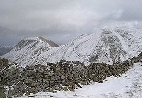
Fairfield (right) and St Sunday Crag, seen from Seat Sandal
|
|
| Highest point | |
| Elevation | 873 m (2,864 ft) |
| Prominence | 299 m (981 ft) |
| Parent peak | Helvellyn |
| Listing | Hewitt, Marilyn, Nuttall, Wainwright |
| Coordinates | 54°29′49″N 2°59′26″W / 54.496883°N 2.990594°WCoordinates: 54°29′49″N 2°59′26″W / 54.496883°N 2.990594°W |
| Geography | |
| Location | Cumbria, England |
| Parent range | Lake District, Eastern Fells |
| OS grid | NY358117 |
| Topo map | OS Landranger 90, Explorer OL5 |
Fairfield is a fell in the English Lake District. It is the highest of a group of hills in the Eastern Fells, standing to the south of the Helvellyn range.
There is a marked contrast between the character of the northern and southern flanks of Fairfield. Alfred Wainwright in his influential Pictorial Guide to the Lakeland Fells wrote that "From the south it appears as a great horseshoe of grassy slopes below a consistently high skyline...but lacking those dramatic qualities that appeal most to the lover of hills. But on the north side the Fairfield range is magnificent: here are dark precipices, long fans of scree...desolate combes and deep valleys."
Fairfield has connecting ridges to several other fells and in plan view can be likened to a bow-tie. The top has an east–west axis with ridges running out north and south from each end.
The two southern arms make up the popular walk, the Fairfield horseshoe, which starts in Ambleside and makes a circuit of the valley of Rydale to the south. On the western side, descending from Fairfield are Great Rigg, Heron Pike and Nab Scar while the eastern ridge bears the tops of Hart Crag, Dove Crag, High Pike and Low Pike.
The north-western ridge of Fairfield crosses Deepdale Hause to St Sunday Crag whilst that to the north east is a short rocky spur into Deepdale, dropping over Greenhow End. A fifth line of high ground, less a ridge than a salient in the breast of the fell, runs due west to Seat Sandal across Grisedale Hause.
...
Wikipedia

