Fairfax Municipal Airport
| Fairfax Municipal Airport | |
|---|---|

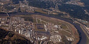
The remaining runway sections of the airport are along the Missouri River (right) and on the north and east of the General Motors Fairfax Assembly Plant (right of center).

Similar northward view in World War II: by 1949 runways were 6,500 ft (2,000 m), 6,100 ft (1,900 m), 5,800 ft (1,800 m), and 4,500 ft (1,400 m).
|
|
| Summary | |
| Airport type | defunct |
| In use | 1921-85 |
| Coordinates | 39°08′53″N 094°35′59″W / 39.14806°N 94.59972°W |
| Map | |
| Located mostly within Kansas, the Fairfax airport was north of the Kansas City Downtown Airport in Missouri. | |
|
|
|
|
|
Fairfax Municipal Airport (Fairfax Field during World War II) was a Kansas City, Kansas, airfield from 1921 that was used during 1935–1949 by the military. Federal land adjacent to the airfield included a WWII B-25 Mitchell plant and modification center and a Military Air Transport terminal. In addition to a Cold War Air Force Base, the military structures at the airfield were used post-war for airliner servicing by TWA and for automobile and jet fighter aircraft production by General Motors, which built a 1985 Fairfax Plant over runways when the municipal airport closed.
The airport site is on the Goose Island (Kansas) river bend. At Goose Island, the United States Government constructed flood protection levees and walls around the Fairfax Industrial District, as well as three pump houses including two on the airfield that was first used for a 1921 "American Legion air meet". The airfield was subsequently used by Emory J. Sweeney's School of Aviation.
Sweeney Airport was named in 1925, and the 403 Pursuit Squadron was assigned to Kansas City at the end of 1925. The "Fairfax plat" map with the airport was drawn on April 1, 1925, as an area "of 1,373.07 acres" outside the city limits divided as follows: "The Kansas City Industrial Land Company owned 1,122.85 acres; the Union Pacific Railroad Company owned 32.80 acres; eight private owners owned 72.18 acres; two railroads other than the Union Pacific owned 66.47 acres; land set aside for dedicated roads was 31.54 acres; [and] land on which dikes were built was 57.23 acres." Sweeney Airport was mapped by the United States Department of Commerce on July 17, 1928, as a trapezoid with 150 acres (61 ha).
...
Wikipedia

