Fair Isle
| Gaelic name | Fara |
|---|---|
| Norse name | Friðarøy/Friðarey |
| Meaning of name | "fair island" or possibly "far-off isle" or "sheep isle". The Norse form Friðarey means literally "calm/peaceful isle" or "island () of tranquility ()". |
 Fair Isle viewed from the west. |
|
| Location | |
|
Fair Isle shown within the Shetland Islands
|
|
| OS grid reference | HZ209717 |
| Coordinates | 59°32′28″N 1°37′23″W / 59.541°N 1.623°W |
| Physical geography | |
| Island group | Shetland |
| Area | 768 hectares (2.97 sq mi) |
| Area rank | 61 |
| Highest elevation | Ward Hill 217 metres (712 ft) |
| Administration | |
| Sovereign state | United Kingdom |
| Country | Scotland |
| Demographics | |
| Population | 55 |
| Population rank | 51 |
| Pop. density | 7.16 people/km2 |
| Largest settlement | Stonybreck |
| References | |

The view eastwards towards the Fair Isle North Lighthouse
|
|
| Location | Fair Isle Shetland Scotland United Kingdom |
|---|---|
| Coordinates | 59°33′08″N 1°36′34″W / 59.552142°N 1.609519°W |
| Year first constructed | 1892 |
| Automated | 1983 |
| Construction | masonry tower |
| Tower shape | cylindrical tower with balcony and lantern |
| Markings / pattern | white tower, black lantern, ochre trim |
| Height | 14 metres (46 ft) |
| Focal height | 80 metres (260 ft) |
| Light source | engine generator |
| Intensity | 204,000 candela |
| Range | 22 nautical miles (41 km; 25 mi) |
| Characteristic | Fl (2) W 30s. |
| Fog signal | 3 blasts every 45s. |
| Admiralty number | A3756 |
| NGA number | 3316 |
| ARLHS number | SCO-078 |
| Managing agent | Northern Lighthouse Board |

Fair Isle South light
|
|
| Location | Fair Isle Shetland Scotland United Kingdom |
|---|---|
| Coordinates | 59°30′50″N 1°39′09″W / 59.513906°N 1.652611°W |
| Year first constructed | 1892 |
| Automated | 1998 |
| Construction | masonry tower |
| Tower shape | cylindrical tower with balcony and lantern |
| Markings / pattern | whute tower, black lantern, ochre trim |
| Height | 26 metres (85 ft) |
| Focal height | 32 metres (105 ft) |
| Light source | wind power engine generator |
| Range | 22 nautical miles (41 km; 25 mi) |
| Fog signal | 2 blasts every 60s. |
| Admiralty number | A3750 |
| NGA number | 3312 |
| ARLHS number | SCO-078 |
| Managing agent | Northern Lighthouse Board |
Fair Isle (Old Norse Friðarey; Scottish Gaelic Fara) is an island in northern Scotland, belonging to the Shetland island group, lying around halfway between mainland Shetland and the Orkney islands. It is known for its bird observatory and a traditional style of knitting.
Fair Isle is the most remote inhabited island in the United Kingdom. It is administratively part of the parish of Dunrossness, Shetland, and is roughly equidistant from Sumburgh Head some 38 km (24 mi) to the northeast on the Mainland of Shetland and North Ronaldsay, Orkney, some 43 km (27 mi) to the southwest. Fair Isle is 4.8 km (3.0 mi) long and 2.4 km (1.5 mi) wide. It has an area of 3 sq mi (7.8 km2), making it the tenth largest of the Shetland Islands. It gives its name to one of the British Sea Areas.
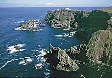
The majority of the islanders live in the crofts on the southern half of the island, with the northern half consisting of rocky moorland. The western coast consists of cliffs of up to 200 m (660 ft) in height, with Ward Hill at 217 m (712 ft) being the maximum elevation of the island and its only Marilyn. On the eastern coast the almost detached headland of Sheep Rock rises to 132 m (433 ft)
Fair Isle has been occupied since the Bronze Age, which is remarkable because of the lack of raw materials on the island, although it is surrounded by rich fishing waters. There are two known Iron Age sites – a promontory fort at Landberg and the foundations of a house underlying an early Christian settlement at Kirkigeo.
Most of the place-names date from after the 9th-century Norse settlement of the Northern Isles. By that time the croft lands had clearly been in use for centuries.
...
Wikipedia

