Fahy
| Fahy | ||
|---|---|---|

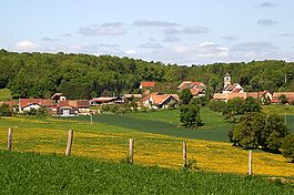
Fahy village
|
||
|
||
| Coordinates: 47°25′N 06°57′E / 47.417°N 6.950°ECoordinates: 47°25′N 06°57′E / 47.417°N 6.950°E | ||
| Country | Switzerland | |
| Canton | Jura | |
| District | Porrentruy | |
| Government | ||
| • Mayor | Maire | |
| Area | ||
| • Total | 7.78 km2 (3.00 sq mi) | |
| Elevation | 567 m (1,860 ft) | |
| Population (Dec 2015) | ||
| • Total | 355 | |
| • Density | 46/km2 (120/sq mi) | |
| Postal code | 2916 | |
| SFOS number | 6789 | |
| Surrounded by | Grandfontaine, Rocourt, Chevenez, Bure, Abbévillers(F) , Croix(F) | |
| Website |
website missing SFSO statistics |
|
Fahy is a municipality in the district of Porrentruy in the canton of Jura in Switzerland.
It was mentioned in 1177 as Fahyl when it was one of the possessions of the priory of Lanthenans. In 1477, the bishop of Basel affirmed the rights of the village. In 1483 it was mentioned as Fahyt.
The village was under the jurisdiction of the bishop of Basel until the end of the 'Ancien Régime'. The village has remained essentially agricultural until 1950. It has undergone modest industrialisation, with the introduction of a Peugeot parts plant. The local church the Church of Saint-Pierre was constructed in 1787-1788 based on the plans of the architect Pierre Francois Paris.
Fahy has an area of 7.78 km2 (3.00 sq mi). Of this area, 4.12 km2 (1.59 sq mi) or 53.0% is used for agricultural purposes, while 1.99 km2 (0.77 sq mi) or 25.6% is forested. Of the rest of the land, 0.67 km2 (0.26 sq mi) or 8.6% is settled (buildings or roads) and 1 km2 (0.39 sq mi) or 12.9% is unproductive land.
Of the built up area, housing and buildings made up 3.7% and transportation infrastructure made up 3.3%. Out of the forested land, 23.5% of the total land area is heavily forested and 2.1% is covered with orchards or small clusters of trees. Of the agricultural land, 37.5% is used for growing crops and 13.6% is pastures, while 1.8% is used for orchards or vine crops. Of the unproductive areas, 10.3% is unproductive vegetation and 2.6% is too rocky for vegetation.
The municipality is located in the Porrentruy district, on border with France, near Montbéliard.
The blazon of the municipal coat of arms is Argent, a Beech Tree Vert trunked and eradicated proper issuant from a Mount of the second.
Fahy has a population (as of December 2015[update]) of 355. As of 2008[update], 5.1% of the population are resident foreign nationals. Over the last 10 years (2000–2010) the population has changed at a rate of -12.4%. Migration accounted for -6.6%, while births and deaths accounted for -1%.
...
Wikipedia


