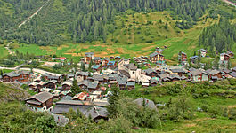
Fafleralp
| Blatten | ||
|---|---|---|
 |
||
|
||
| Coordinates: 46°25′N 7°49′E / 46.417°N 7.817°ECoordinates: 46°25′N 7°49′E / 46.417°N 7.817°E | ||
| Country | Switzerland | |
| Canton | Valais | |
| District | Westlich Raron | |
| Government | ||
| • Mayor | Lukas Kalbermatten | |
| Area | ||
| • Total | 90.65 km2 (35.00 sq mi) | |
| Elevation | 1,542 m (5,059 ft) | |
| Population (Dec 2015) | ||
| • Total | 288 | |
| • Density | 3.2/km2 (8.2/sq mi) | |
| Postal code | 3919 | |
| SFOS number | 6192 | |
| Surrounded by | Baltschieder, Fieschertal, Kandersteg (BE), Lauterbrunnen (BE), Naters, Raron, Wiler (Lötschen) | |
| Website |
www SFSO statistics |
|
Blatten is a village and municipality in the Lötschental valley in the canton of Valais in Switzerland. It is part of the district of Westlich Raron, and much of the municipality lies within the Jungfrau-Aletsch protected area, a World Heritage Site. Besides the village of Blatten, the municipality includes the settlements of Eisten, Fafleralp, Ried and Weissenried.
Blatten should not be confused with the ski resort and village of Blatten bei Naters, which lies some 15 kilometres (9.3 mi) to the south-east in a direct line, or nearer 50 kilometres (31 mi) by road.
Blatten is first mentioned in 1433 as uffen der Blattun.
The blazon of the municipal coat of arms is Azure, a rocky Mountain Argent issuant from the flank dexter and from the point, per bendwise and in chief sinister a Cross bottony of the same.
Blatten lies in the Lötschental valley south of the Bernese Alps. The municipality is located in the Westlich Raron district, and is the highest inhabited part of the Lötschental valley at an elevation of 1,540 m (5,050 ft). It consists of the village of Blatten and the hamlets of Eisten, Ried and Weissenried. At the head of the road up the valley, Fafleralp is the site of a well known hotel.
The Jungfrau-Aletsch protected area, includes most of the municipality, although excluding the main settlements. At the head of the Lötschental valley, the Lötschenlücke pass, into the valley of the Aletsch Glacier, forms the municipal boundary. Below this pass, the Langgletscher glacier occupies the Lötschental valley, whilst the Schwarzsee lake lies at a lower level. The valley is framed by the Tschingelhorn to the north and the Bietschhorn to the south, and the slopes of both mountains lie within the municipality.
...
Wikipedia


